Commerce in old Phoenix

Commerce in old Phoenix

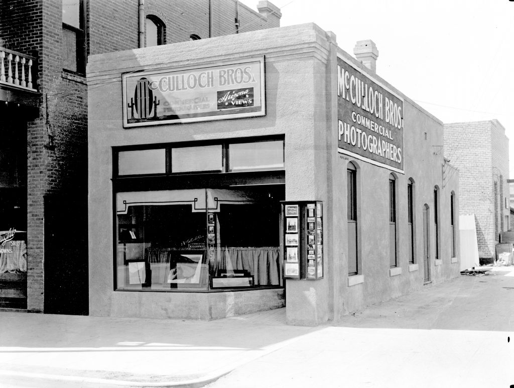
The McCulloch Brothers, who have left a priceless archive at ASU, were primarily commercial photographers. Their work, which spans from 1884 to 1947, offers a variety of images of business in the young, growing city. Most of this gallery is thanks to them.

You can read about the decades on these earlier history columns: Phoenix at statehood, the twenties, the thirties, the forties, and the fifties. Enjoy and click on the photo for a larger image.

McCulloch_Brothers_Photography_studio_18_N_2nd_Ave_1920s(1)

The McCulloch Brothers photography studio, 18 N. 2nd Avenue, in the 1920s.

Apache Trail Stage McC

A downtown sidewalk scene circa late 1910s with the Arizona Cigar Co. and the Apache Trail Auto Stage Co.

Washington St 1928
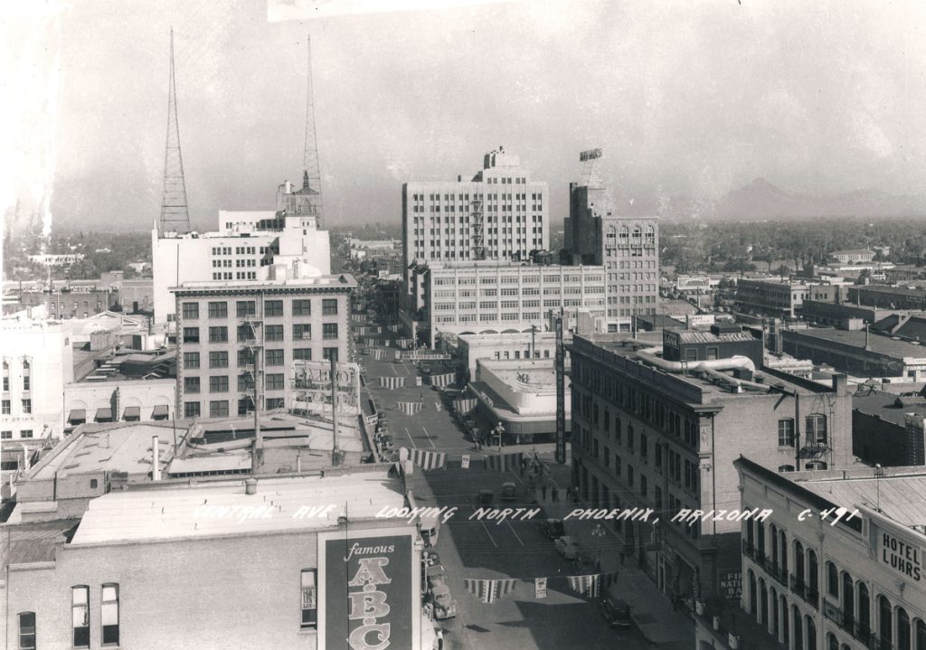
Washington Street, the city's main commercial drag in 1928. Awnings helped keep pedestrians cool.

Floyd_Ikhard_Household_Appliances_831_N_1st_Ave_1945(1)

Floyd Ikhard Household Appliances, 831 N. 1st Avenue, in 1945.

Barker_Bakery_123_N_1st_Ave_1940s(1)

Barker Bakery, 123 N. 1st Avenue, in the 1940s.

OverlandMotors_10WVanBuren_1920sOverland Motors at 10 W. Van Buren in the 1920s. These blocks of the city would become the main location of auto dealers.

Phoenix_Motor_Company_Chevrolet_Buick_401_W_Van_Buren_1940sPhoenix Motor Co., a GM dealership, was at 401 W. Van Buren Street. It's been restored as The Van Buren, a concert venue.

Miracle Mile

Miracle Mile

I don't know when the stretch of east McDowell from 10th Street to beyond 16th Street received this nickname. It's certainly not the legendary shopping destination of Chicago. But I do know it was Phoenix's first major retail-commercial artery outside of the downtown central business district. (Grand, Van Buren, and 17th Avenue/Buckeye were mostly motels, restaurants, and "curio" shops for travelers).

The Miracle Mile was special because it had an urban fabric missing from any other part of the city outside, even Midtown and Uptown on Central Avenue. The commercial buildings were densely packed, most right up on the sidewalk. McDowell was only four lanes wide. The result was walkability missing in most parts of a city built for the automobile.

McDowell's businesses continued beyond 16th Street and, going west, to Seventh Avenue. However, the Miracle Mile most exemplified urban authenticity. No wonder efforts are under way to reinvent the stretch. Included is a public art arch. Sadly, they face the headwinds of demolished buildings and a six-lane McDowell which is much more dangerous for pedestrians, especially at night.

A footnote: When I was around nine some friends and I rode our bikes along the mile, then turned around and came back — on the sidewalk but against traffic. I raced to catch up with them when a car pulled out from a side street. I hit the fender and tumbled over the hood, landing on the pavement. The terrified driver picked me up from the asphalt (which you shouldn't do) and carried me to the sidewalk. There an ambulance (Phoenix Ambulance, where I would work a decade later) took me to Good Sam to await my mother and grandmother. I got away with a mammoth bruise on my upper leg.

Come with me on a tour of the historic Miracle Mile (click for a larger image):

Kenilworth centennial

Kenilworth centennial

Kenilworth_Elementary_School_(2)
My name and graduation date are etched in one of these bricks, which were installed to mark the 80th anniversary of my alma mater. I was honored to be one of the speakers. As for the bricks, they looked poorly carved so you might have to look hard to find those of us who paid to have our names on them. But the important thing is that Kenilworth survives, thrives, and this year celebrates its 100th anniversary.

Kenilworth was the grandest of several handsome elementary schools completed in that era, including Monroe, Grace Court, and Booker T. Washington. It was in the neighborhood that initially had the same name, where Phoenix's elite moved. Now it's the Roosevelt and F.Q. Story historic districts. But that, and the ill-considered Papago Freeway inner loop, were far in the future in 1920. Then the streetcar ran along Fifth Avenue.

By the time I came along, in the 1960s, the streetcar was gone. But Third Avenue ran straight in front on the school, no curve for the freeway onramp. Seventh Avenue was only four lanes wide with a friendly crossing guard named Paul. We lived on Culver Street when I was in first and second grades, then moved to Cypress in today's Willo historic district for the remainder of my time there.

More shots in the ’30s and ’40s

More shots in the ’30s and ’40s

Golden West Hotel
A few days ago, we lost the Golden West Hotel, formerly the Steinegger Lodging House, at 27 E. Monroe Street and built in 1889. It held Newman's cocktail lounge as late as 2005. But even with all of Phoenix's losses, the preservation police could not save the oldest building in downtown. Duran Lugo documented this act of civic vandalism on Facebook's Phoenix Shadetree History page.

In memory, let me clear my desktop of some historic Phoenix photos that likely haven't been on this site before (click for a larger view)

. And a final thought: If the Golden West isn't safe, what about Union Station?

7th_Ave_looking_north_towards_Osborn_1940sThis is Seventh Avenue looking north toward Osborn in the 1940s. The image perfectly captures old rural Phoenix, including abundant shade trees. No palo verdes of gravel to be seen.

Busy Central-Washington 1940sBusy Central and Washington in the same decade. Unlike today's suburban feel, downtown looked like the business core of a real city.

Central_Monroe_looking_south_South_Mountain_1940s(1)Thanks to Brad Hall, here's a high-resolution shot from Monroe and Central looking toward the South Mountains in the '40s. Note the Santa Fe Railway ticket office in the Professional Building. A few steps farther to the left is the Golden West. South of the Professional Building is the Hotel Adams, demolished in the 1970s.

The skyline through time

The skyline through time

In a column last year, I explained why Phoenix lacks the skyscrapers that are the defining feature of big cities. Why? It's complicated. Now, let's look at the Phoenix skyline through the years. Click on the image for a larger view.

Phoenix_downtown02Looking north on Central from Jefferson Street, we see Phoenix's first real skyline that emerged in the 1920s building boom. At left with radio towers is the Heard Building and beyond it the cap of the Security Building. At left, beyond the Hotel Adams, is the Professional Building.

Luhrs Tower from parkSeen from the Courthouse Park, the Luhrs Building and art deco Luhrs Tower were among the most iconic structures from the 1920s skyline.

LuhrsBuildingAnother shot, this time from the Hotel Luhrs balcony, showcases the Luhrs Building and beyond it the Luhrs Tower.

Days of rage

Days of rage

Jon Talton_Charles Blonkenfeld photo

Former Arizona Attorney General Grant Woods got it right when he tweeted, "We need to support and defend every protester. And we need to arrest and prosecute every single person who loots or damages private property. We can do both. We have to do both."

My two cents, after watching both peaceful protests and then the worst rioting and looting in modern Seattle history (yes, worse than the 1999 WTO): The events of the past several days are a combination of outrage over the murder of George Floyd by a Minneapolis police officer, criminals who took advantage of the situation, Trump, and cabin fever from weeks of Covid-19 lockdown.

As for Phoenix, it has a downtown again. I remember when pitiful protests against George W. Bush were held on the sidewalk at 24th Street and Camelback. Now, downtown has come back sufficiently to be a dense core and offer public spaces (and police headquarters, above) to see protests and damage similar to real cities. The rocks regrettably come with the farm.

I can't think of any analogy in the city's history. When Martin Luther King Jr. was assassinated in 1968, a disturbance around Eastlake Park was quickly put down and Mayor Milt Graham and black ministers held a community meeting to encourage calm. Now Gov. Doug Ducey has imposed a statewide curfew without consulting the mayors of Phoenix or Tucson.

Phoenix in the ‘teens’

Phoenix in the ‘teens’

Phoenix circa 2010s
In 2010, Phoenix and Arizona were stuck in the worst (by most measures) bust since the Great Depression. Unemployment peaked at 10.9% in January statewide and 10.2% in metro Phoenix. Single-family housing starts in the metro area plunged from a monthly peak of 6,000 in 2004 to 854. Construction jobs fell from 183,000 in June 2006 to 81,000 in the summer of 2010. Phoenix was a national epicenter of the housing crash.

It was an eerie time. Freeways that had been clogged with tradesmen's pickup trucks were noticeably empty.

Now, nearly a decade later, the economy has recovered. Metro Phoenix joblessness was 4.1% in October, higher than the 3.6% nationally but still a marked improvement. Building permits clawed out of the 2009 trough but are still at levels of the early 1990s.

Population — the holy of holies worshipped by the local-yokel boosters — bounced back. After falling from 2008 to 2010, it rose by 653,000 by 2018 in the metro area. A much ballyhooed snapshot had the city itself the fastest-growing in the United States from 2017 to 2018. But the percentage rate of change looks to be slower this decade than the 2000s or the record 1990s.

True, the decade doesn't officially end until a year from now. But the "twenties" begin in the popular imagination this New Year's. So let's take stock of the "teens":

St. Luke’s memories

St. Luke’s memories

St_Lukes_Hospital_Fillmore_18th_Street_looking_east_1960s
Town DitchSt. Luke's Hospital was built on the ruins of the dense Hohokam village called La Ciudad. It tilts at an angle because it had to fit against the original canal dug by Jack Swilling and his gang from Wickenburg. The Town Ditch or Swilling's Ditch was covered in the 1920s but Villa Street preserved the angle. Today's St. Luke's extends all the way to Van Buren Street with a ghastly spread of rocks and gravel. Yet the hospital you see above was built in the shady Montezuma Heights barrio
of houses and public housing projects south of Edison Park. No gravel.

In my time on the ambulance, I spent a good amount of time at the emergency room of St. Luke's (or, as we called it with our dark humor, St. Puke's). In the New Testament, Luke the Evangelist was referred to as a physician.

Once, we heard an explosion outside and went to check what had happened. A patient had thrown himself off an upper floor and was well beyond our ministrations. On a happier note, we regularly had lunch (Code 7) at nearby Sevilla's (before it moved to McDowell), a family-owned Mexican restaurant surrounded by the 'Jects. The homeboys kept watched over our units so they wouldn't be broken into for drugs or stolen.

Off duty, I would visit my mother there, in her twice-annual stays as a patient, being treated for the emphysema that would kill her within a few years. The care was good.

I write all this because, after a century at this location, St. Luke's is closing.

The war on shade

The war on shade

Arizona Ash 1

Behold the lovely Arizona ash tree in the photo above (thanks to Aimee Esposito, executive director of Trees Matter). Elsewhere, mature pine trees will soon be demolished if a plan is approved for Shepherd of the Valley Lutheran Church to use half its land in the Alhambra district for single-family houses in a gated property. WWJD?

Like the newspaper business, mainline Protestant churches are in such a catastrophic decline, much of it self-inflicted, that their most valuable earthly possessions are their property. But this latest abomination, reported by New Times, is part of an ongoing catastrophe that is going to help make Phoenix uninhabitable in the future — and is helping raise local temperatures now, not to mention making most of it remarkably ugly.

Most Phoenicians today likely have no memory of the old city, a lush Eden of trees, grass, hedges, flowers, citrus groves, farms, and the priceless Japanese gardens. This was made possible now only because of our federally funded water projects, but also because the heart of the Salt River Valley is a natural oasis, near the confluence of five rivers and sitting on some of the most fertile alluvial soil on earth. Growing up, I never saw one palo verde, most varieties of which provide zero shade, outside of going into the desert.

Today, Phoenix is ever more a paved monstrosity of asphalt, concrete, and grass, with the occasional "shade structure" which doesn't actually provide shade. Not surprisingly, overnight temperatures have risen 10 degrees in my lifetime. Losing the regular frosts once commonplace, West Nile virus is a new scourge, carried by mosquitoes that were once killed off in winter. And this is before the rising dangers of climate change.

Snakebit

Snakebit

1024px-Chase_Field_-_2013-05-24_-_Section_118
I've spent a good part of my career advocating public funding for stadiums as a necessary evil to protect important civic assets. For example, I supported new stadiums for the legendary Reds and the perpetually disappointing Bengals ("Bungles”) when I was in Cincinnati. These new venues kept pro teams that would have otherwise decamped for larger markets.

I did it again most recently with the Phoenix Suns arena, arguing in November that allowing the NBA team to leave downtown would be a terrible blow to the central city:

Kate Gallego, facing Daniel Valenzuela in a March mayoral runoff, said, “it is not in Phoenix’s best interest to invest in an arena.” Arizona Republic columnist Laurie Roberts wrote, "taxpayers are about to get hosed if this deal goes through."

Here's the real deal: If Phoenix doesn't invest in the arena, Sarver — who has none of Jerry Colangelo's civic spirit — will move the team to the Rez, renaming it the Arizona Suns, no doubt, or even to Seattle, which is hungry to replace its lost Supersonics. The damage to downtown and light-rail (WBIYB) would be catastrophic. Talk about hosed.

Now come the Diamondbacks, demanding further pro-team welfare. The team can leave Chase Field as early as 2022 and has been sending ominous threats: Exploring use of the Cardinals stadium in Glendale for while, flirting with the Las Vegas area, fielding feelers from other cities. The most comfort officials would give is that the D-backs "are highly likely to remain in Arizona."

And I'm starting to think: Git. Let. Them. Leave.

The plot against light rail

The plot against light rail

LRT downtownThis is the reality of Phoenix's light-rail system: nearly 16 million passengers carried in the most recent fiscal year; expansion of the original 20-mile starter line to 26 miles; an essential link between ASU's Tempe and downtown campuses; 30 percent of riders use the train for work; large numbers use it to reach sporting events; $11 billion in private and public investment has occurred along the line since 2008.

Light rail has also proved essential in giving Phoenix, Tempe, and Mesa a fighting chance in an era where talented young people and high-quality companies want to be in city cores served by rail transit.

None — not one — of the hysterical predictions of opponents to light rail came true.

No wonder that voters backed light rail in three elections, in 2000, 2004, and 2015. We built it.

But destructive forces never sleep, never stop. Backed by dark money — including the Koch brothers and their nationwide war on transit — here comes Proposition 105 in the Aug. 27th special election. As is often the case, it's presented as an affirmative to deliberately confuse voters. "Vote yes!" hoping some will think they are supporting rail transit by marking that line. Signs say, "Yes on 105. Fix our roads" — but this has nothing to do with fixing roads; that's a different budget and roads are being fixed.

Don't fall for it. Vote no on Prop. 105 and its devilish companion, Prop. 106.

Big preservation alert

Big preservation alert

Union Sta arches
The most precious treasure of old downtown Phoenix is in flux. This could provide the city a long-overdue opportunity. Or it could go sideways in a hurry. I'm writing, of course, about Union Station.

According to CBRE, the big real-estate services firm "has been retained as exclusive representative to offer qualified investors the opportunity to purchase fee interest in the iconic…Union Station site in downtown Phoenix at 401 W. Harrison Street." It goes on, "Depending on the vision of a new owner, the Property may be eligible for a myriad of monetary and tax advantaged programs…"

Sprint, which has used the station to house switching equipment since the late 1980s, intends to move out before the end of next year. The Union Pacific Railroad's ground lease ends in March 2023, a century after the building was completed. Now what?

One of the most popular columns on this site is my history of Union Station (with photos) — you can read it here. The Spanish revival building brought together the Southern Pacific and Santa Fe railroads in one full-service station. Three years after its completion, the SP finished its northern main line and routed most of its passenger trains through Phoenix. The city was served by multiple intercity trains a day through the 1960s.

The last Amtrak train called here in 1996. The state refused to partner with the SP (merged with Union Pacific the same year) to maintain the west line between Phoenix and Wellton to passenger-train standards. Phoenix became the largest American city by far with no intercity rail service. Sprint — which was started by the SP — using the depot for switching equipment helped protect and save it. Being on the National Register of Historic Places wouldn't have stopped Joe Arpaio's jail-building mania and other losses in the Warehouse District. Mesa lost its lovely SP depot to arson…no one cared.

Who will care now?

The Post Office

The Post Office

Phoenix-US_Post_Office-1932-1
A conversation on one of the Phoenix history pages of Facebook got me thinking about the thousands of cuts that bled downtown nearly to death. It was about the old Main Post Office at Central and Fillmore, now mostly used by ASU but contained some incomplete or wrong information. Still, a useful jumping off point.

Back in 2013, I wrote a three-part series entitled "What Killed Downtown" (see here, here, and here). It's still the gold standard on the subject. But the tale of the Post Office illuminates it in microcosm.

This lovely Spanish-revival building was completed in 1936, designed by Lescher & Mahoney, the architects responsible for many of Phoenix's finest buildings. Among them are the Orpheum Theater, Brophy College Chapel, El Zariba Shrine Auditorium (former home to the Arizona Mining and Mineral Museum), Phoenix Title and Trust Building (today's Orpheum Lofts), Hanny's, and the Palms Theater.

It was planned in the 1920s to replace the Post Office segment of the old Federal Building in the government block at Van Buren and First Avenue. With Sen. Carl Hayden's backing, it was originally intended to be six stories tall and closer to the central business district. But because of expensive land, the site was move north across from the new Westward Ho and the height was lowered. Building it was among the myriad federal projects that lifted Phoenix out of the Great Depression.

The oasis, in photos

The oasis, in photos

40&Baseline_1970s jpg
My mother told me I was "a city kid" and a "desert rat." She was right about the first, but not the second. I was a child of the oasis, growing up in what are now the historic districts north of downtown and in the old city.

It's almost all gone now. Every time I'm back in Phoenix, I am struck my how ugly it is, especially with the proliferation of skeleton trees and heat-radiating gravel in places they should not be. If this is the price paid to accommodate ever-expanding sprawl, it's a devil's bargain, a short hustle. With the enormous numbers of newcomers and population churn, people don't even know what has been lost.

One of the most heartbreaking losses was the Japanese flower gardens along Baseline Road.(above). An agricultural trust could have prevented it. But the feral greed to replace it with faux Spanish-Tuscan crapola was too much to overcome.

A reminder: Phoenix is at or near the convergence of five rivers in the world's wettest desert. Scores of shade trees are native. With the alluvial soil of the Salt River Valley, anything will grow here.

But as on the national level (only 26,000 history majors now), the loss of memory is a dangerous thing. Milan Kundera, the Czech novelist, wrote that the struggle of man against power is the struggle of memory against forgetting. Thanks especially to the priceless McCulloch Bros. Collection at the ASU archives, we can struggle. I only wish more of these images were in color.

Here are a few views of authentic Phoenix. Click on an image for a larger view: