Washington through the years

Washington through the years

No east-west street was more important to early Phoenix than the one named after our first president. It carried streetcars, was the heart of the business district, held important buildings, and was movie-theater row. Washington remains the north-south dividing line for street addresses (Central is east-west). Let's take a tour through time.

Washington_Central_north_side_of_Washington_19011901: A dusty road with horses and mule-drawn streetcars.

Washington_1st_St_Goldberg_Bros_parade_Indian_and_Cowboy_Carnival_19031904: The Indian and Cowboy Carnival Parade.

Washington_1st_St_looking_west_street_cars_1905
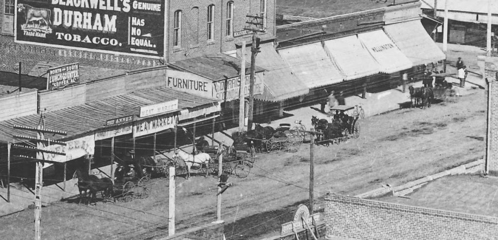
1905: At First Street looking west.

The data center hustle

The data center hustle

Datacenter
Data centers becoming dominant force in Mesa," reads the headline on a recent East Valley Tribune story. The lede: "It may never rival Silicon Valley, but Mesa is fast becoming Data Center Alley." 

This "Alley" isn't transforming struggling west Mesa and it's nowhere near the light-rail line. Instead, it's centered on the "Elliott Avenue Technology Corridor" in far southeast Mesa, the location of agriculture, desert, and the former Williams Air Force Base. Now, with abundant concrete, gravel, and asphalt, it will expand the increasingly dangerous Phoenix urban heat island. The "Corridor" is entirely car dependent.

Data centers are lowest on the ladder of the tech economy: necessary, but bringing few jobs — much less high-end jobs — and several headaches. This is why they are usually found in rural areas desperate to replace their lost millwork, manufacturing, or railroad jobs. States and localities shell out huge incentives and disappointment follows.

But to see the proliferation of data centers in a city the size of Mesa (518,000 in 2019), in the 10th most populous metropolitan area in the nation, is curious.

Duke and more Ponzi dreams

Duke and more Ponzi dreams

Duke Photography building
Duke signThe news from my old 'hood is the pending demise of the Duke Photography building on the southwest corner of Seventh Street and Thomas. The Arizona Republic reported the building is set to be demolished and a Raising Cane's Chicken Fingers drive-thru built on the site. Duke is moving to the First Federal Building on Central in Midtown, taking its sign with it.

This is wrong for so many reasons, no wonder nearby neighborhood associations are opposing it ahead of a June 17th virtual public hearing. One big concern is increased traffic, including dangerous turns on Seventh, which has been widened and had "suicide lanes" added for rush hour. A Kentucky Fried Chicken drive-thru on the northwest corner already causes collisions.

Beyond that, while the building is modest it fits into the remaining fabric of the streetscape. The Raising Cane would be another soulless off-the-shelf building, made for cars not for pedestrians. If the company really wanted to be a good neighbor, as it claims, it would build something appropriate to the nearby historic districts. Too many losses have already been allowed, notably the replacement of John Sing Tang's iconic Helsing's at Central and Osborn — right up to the street — by a Walgreens, set back by a surface parking lot and surrounded by a low wall, gravel, and rocks.

Early Phoenix mapped

Early Phoenix mapped

One of the most interesting sources of information on early Phoenix can be found on the Library of Congress' Sanborn Fire Insurance Maps. The Sanborn Map Co. produced detailed maps of 12,000 U.S. cities and towns, detailing not only buildings but in many their construction materials so insurers could assess their risks.

Below I have some views of Phoenix, one in 1911 and the remainder from 1949, focused on Union Station and the Warehouse District. Click for a larger image.

Sanborn block 77 1911

Sanborn Warehouse 1

6a00e54ee025588834026bdecd130d200c

Russell Lee’s Phoenix

Russell Lee’s Phoenix

512px-Russell_LeeIn 1940, photographer Russell Lee visited Phoenix. His main task was taking pictures of Farm Security Administration projects in the city. He joined such distinguished federal photographers as Dorothea Lange and Arthur Rothstein.

The FSA was created in 1937 to help ease rural poverty. Among its signature Phoenix operations were Camelback Farms, northeast of downtown and intended to create a stable environment for displaced farm families, and the United Producers and Consumers Cooperative, with about 12,000 members, mostly farmers.

But the trip yielded much more, including some iconic images of Phoenix as the Great Depression was loosening its grip and war was looming. Born in Ottawa, Illinois, in 1903, Lee died in Austin in 1986. 

I've written about Phoenix in the 1940s here. Below is some of his work from the Library of Congress. Click on an image for a larger view.

Sign outside Phoenix 1940

Welcome sign outside of town, with the meeting days, times, and places of service clubs.

Central and Phoenix 1940

Central and Washington, with Lerner Shops, movie theaters, and streetcar tracks.

Cactus Streetlight 1940

The famous saguaro streetlamp across from the Hotel Westward Ho. Only one was made, outside the Chamber of Commerce.

‘See me AZ’

‘See me AZ’

McDowell_10St._1960
This is the name for a new campaign to reduce pedestrian and bicyclist deaths on the streets of metropolitan Phoenix. As KTAR reported, “ 'See Me AZ' aims to educate people on research that indicates most crashes occur when drivers, cyclists or pedestrians don’t see each other."

I'm not hopeful.

However it's counted, Phoenix and Arizona rank high among the most deadly places for pedestrians. Fifth worst in the nation in 2018, according to the Governors Highway Safety Association. Deaths totaled 106 for the first six months of 2020 (Colorado 39; Washington 47). The federal Traffic Safety Administration ranked us fourth worst in 2018. A compilation by the Arizona Republic found a stunning 1,202 pedestrians killed by motorists between 2014 and 2019.

From the late 1940s onward, Phoenix streets were widened, especially to move vehicles quickly out of downtown (collateral damage was the loss of thousands of real shade trees). McDowell Road, shown above in the 1960s, is now two lanes or wider. This remains one of the scariest avenues for pedestrians or watchful drivers, especially between 56th Street and 24th Street, where the night swallows the inadequate illumination from too few street lamps.

The result today is that metropolitan Phoenix is a collection of real-estate ventures connected by wide highways called "city streets." Where Thomas Road crosses Central, it's about twice as wide as a major downtown street in Seattle. The "walk" signal lasts barely long enough to accommodate those wishing to cross and drivers frequently turn without looking. On any given day or hour, the Phoenix Fire online regional dispatch log shows "962 w. pedestrian" (a 962 is the radio code for auto collision with injuries).

Police and fire in early Phoenix

Police and fire in early Phoenix

Henry Garfias
Henry Garfias, the son of a Mexican general, was elected Phoenix's first town marshal in 1881. Already famous for apprehending the stagecoach "ghost bandit" as a county deputy, Garfias (above, courtesy of Duran Lugo) was said to have shot dead several outlaws as marshal and brought order to Washington Street's Whiskey Row (16 saloons and four dance halls). Thus was born the Phoenix Police Department.

The department operated out of the old City Hall until it received a more modern space in the City-County Building in 1929. Call boxes were used throughout the city for officers to check in. Phoenix equipped its squad cars with radios in 1932. You can learn more about PPD's history from the Phoenix Police Museum, located in the 1929 Police Headquarters at 17 S. Second Avenue. My new novel, City of Dark Corners, is set in the Depression-era department.

The Phoenix Fire Department came from passage of a bond issue in 1886 to establish a volunteer fire service with modern equipment and an improved water supply. Still, two hose companies (one Anglo, one Hispanic) competed until Frank Czarnowski joined them together as the Phoenix Volunteer Fire Department in 1888. By 1922, it was a paid, full-time department.

Here are some early photos (click for a larger image):

Nott steam fire engine

A Nott steam fire engine, one of Phoenix's first (City of Phoenix).

Fire_Station_horses_1st_St_Jefferson_1908_SHR copy

Horse-drawn apparatus at Fire Station No. 1, First and Jefferson streets, in 1908 (McCulloch Bros. Collection/ASU Archives).

Toward a desert aesthetic

Toward a desert aesthetic

Tucson barrios
Once upon a time defining beauty in Phoenix was relatively easy. The old city was shady, grassy, and well landscaped. From there moved circles of citrus groves, flower fields, pastures, and farms in one of the most fertile alluvial river valleys in the world, and finally stark beauty and abundance of plant and animal life in the wettest desert in the world. No other city looked like Phoenix. It was magical and lovely.

Now this is largely gone. Even in the historic districts ahistorical desert landscaping is creeping. For most of the metropolitan area, built an acre an hour, the look is concrete, asphalt, gravel, and shadeless palo verde trees. Oh, and "shade structures" that provide little shade. Lookalike faux Tuscan tract houses in "master planned communities" offer postage-stamp lawns and wide driveways (the old driveways in Willo were two strips of concrete). Tens of thousands of shade trees have been felled, whether by diktat of the Salt River Project or to create the six-lane-plus highways called "city streets."

Curiously, these single-family houses are built on the same layout as most American homes. But with gravel instead of a lawn. No wonder the temperature has risen 10 degrees over the past 50 years and the summers last longer. When I was given a tour of Verrado — where David Brooks saw the future — the developers bragged how they had copied Palmcroft, for that was the kind of living their surveys showed buyers wanted. But it doesn't work, for this sunblasted development in Buckeye lacks the real Palmcroft's beautiful trees, grass, hedges, and flowerbeds.

Rural scenes of old Phoenix

Rural scenes of old Phoenix

Before "master planned communities," freeways, gravel, palo verdes, and endless pavement, Phoenix was closely surrounded by groves and farms, shade trees and virgin desert. It lasted until the 1960s and 1970s. I remember my grandmother taking me for a picnic on a dirt road surrounded by fields and beneath a cottonwood tree. Here are a few of the photos (click for a larger image):

Country_Road_Salt_River_Valley_1909(1)

Central and Southern 1930

Arizona willows or ash trees line Central and Southern avenues, 1930 (McCulloch Bros. Collection/ASU Archives).

Central and Southern 1930.jpg

Another view of shady Central at Southern in 1930 (McCulloch Bros. Collection/ASU Archives).

LincolnDriveWestof ScottsdaleRd_1935

Lincoln Drive west of Scottsdale Road in 1935.

Orangewood Ave. 1939

Orangewood Avenue in 1939 (McCulloch Bros. Collection/ASU Archives).

Degrading by degrees

Degrading by degrees

Glendale CC
When the Republican-controlled Legislature isn't busy with voter suppression laws or bills to further the National Rifle Association wish list, it can still make time for brilliance such as this: Allowing community colleges to award four-year degrees.

Legislation to make this possible has passed the state House, the furthest it's gotten in years of being repeatedly introduced. It might pass the Senate. Moving the proposal this far required compromises with the Board of Regents. As Howard Fischer of the Capitol Media Service reported:

The colleges can’t just get into the business. Instead, it requires studies to determine if the colleges, supported largely with local tax dollars, can hire the necessary faculty and sustain the programs. There also has to be a determination that the degrees offered will meet needed fields and whether they would “unnecessarily duplicate” programs already offered elsewhere. And there’s no authority for new property taxes.

There’s an extra hurdle in HB 2523 for the colleges in Pima and Maricopa counties. They could initially offer only a limited number of four-year degrees, defined as no more than 10% of total degrees offered for the first four years and 15% for years five and beyond.

Mac

Mac

48385338_2312414719014622_7917882964497661952_o
When today's Arizonans think about the state's most important U.S. Senators, they go to Barry Goldwater and John McCain. A few will remember Carl Hayden, one of the longest-serving members of the Senate and, after the assassination of President John F. Kennedy, third in the line of succession to the White House.

Yet Goldwater, although the father of the right-wing takeover of the Republican Party, had a thin layer of legislative accomplishments, and McCain did almost nothing for the state he made his home. Hayden was undeniably the most important figure in winning the Central Arizona Project in Congress.

The Arizona Senator who casts the longest shadow of accomplishments is nearly forgotten: Ernest McFarland. First elected in 1940 when he defeated incumbent Henry Fountain Ashurst, Mac was an important partner with Hayden in fighting for Arizona's share of Colorado River water. His most significant accomplishment was sponsoring the GI Bill, which provided benefits for returning benefits for returning World War II veterans, including educational benefits.

Mac was the father of the GI Bill. He also served as Senate Majority Leader from 1951 to 1953, followed by Lyndon Johnson.

Supersized

Supersized

Mesa_Main_St_Macdonald_looking_northeast_1940s

It's difficult to find another major metropolitan area where most of the suburbs are as populous as in Phoenix.

Consider: The "town" of Gilbert alone held more than 254,000 people as of 2019. It's only the fifth-largest municipality in metropolitan Phoenix, but larger than all but two cities in Los Angeles County: LA and Long Beach. Mesa is the 35th largest city in America, at more than 518,000 — larger than Cleveland, Cincinnati, St. Louis, Minneapolis and a host of better-known cities.

This is very different from the pattern in most metros. Older eastern and Midwestern areas consist of large numbers of small suburbs and a large center city. That star may have dimmed, as in Detroit or St. Louis, but none of their planets are anywhere close on population. The same is true in Atlanta, with a relatively small city of 507,000 in a metro of 6 million, but no individual suburb comes close. Charlotte, the 15th most populous city in the country (886,000), essentially annexed its entire county.

Phoenix's populous suburbs weren't always this way. These were once individual towns in the Salt River Valley, separate from each other, with different histories, dependent on agriculture and railroads. Above is Main Street in Mesa 1940, when the population was 7,200. This separation was evident well into the 1960s.

When Midtown cooked

When Midtown cooked

GB Bldg 1964


Midtown wasn't planned. It simply escaped…any coherent city planning, zoning, or vision. Some say it was Phoenix's attempt at Los Angeles' Wilshire Boulevard, the nearly 16-mile avenue from downtown LA's financial district to Santa Monica. Maybe. But Phoenix never had the economic power or urban assets to support its version of Museum Row on the Miracle Mile, Century City, Koreatown, Beverly Hills, Westwood with UCLA, and subway lines. Wouldn't want to become another LA.

The two are comparable in that both were the sites of a majority of post-1960 skyscrapers. In Phoenix, it began with the building above. A turquoise-skinned International-style box, the Guaranty Bank Building opened in March 1960, designed by architect Charles Polacek and built by contractor David Murdock (who lived a remarkable life). At 252 feet, it dethroned the Hotel Westward Ho as the tallest building in Phoenix and the Southwest. On the top floor the Cloud Club offered a spectacular view.

Over the next thirty or more years, this was the heart of the city. For better and for worse.

The Camelback Towers was also complete in the photo (a mile north at Pierson). Park Central Shopping Center had replaced the Central Dairy in the late 1950s. Del Webb's Phoenix Towers at Central and Cypress Street, one of the few co-ops in the city, opened in 1957. Twin mid-rise office buildings were opened two blocks south of Thomas; they eventually included U-Haul's headquarters. Midtown, still unnamed, was coming together haphazardly. The central business district, including most shops and department stores, were still downtown (Fillmore to the railroad tracks, Seventh Avenue to Seventh Street).

Arizona’s pandemic economy

Arizona’s pandemic economy

The longest economic expansion in history crashed into recession this spring because of the COVID-19 pandemic. Unemployment skyrocketed to Depression-era levels before recovering…some. Industries such as airlines, hotels, tourism, restaurants, and brick-and-mortar retailers were savaged.

I've written about this extensively in my Seattle Times columns. But let's narrow the lens to Arizona and Phoenix with help from the invaluable data collected by the Federal Reserve Bank of St. Louis (FRED). Click on the chart for a larger view.

Unemployment:

FredgraphUNEMP

FredgraphPHXjobs

Population growth (by numbers and year-over-year percentage change:

FredgraphAZPOP

FredgraphAZPOP2

Phoenix’s historic schools

Phoenix’s historic schools

1873 adobe schoolhouse Central Monroe

Once upon a time, schools weren't built to resemble prisons with walls and steel fences, along with no shade and heat-radiating concrete and gravel. Even in early Phoenix, most were built to inspire. In 1873 (above) an adobe school at Central and Monroe was the beginning of better to come. Here are a few — click on the photo for a larger view:

Central School  Central and Monroe  1899

Central School, shown in 1899, replaced the adobe structure. The town's population was about 5,500.

Monroe School 1914 postcard

Monroe School at Seventh Street and Monroe, 1914. The building was preserved and is now the Children's Museum of Phoenix, alas without the shade trees and grass.