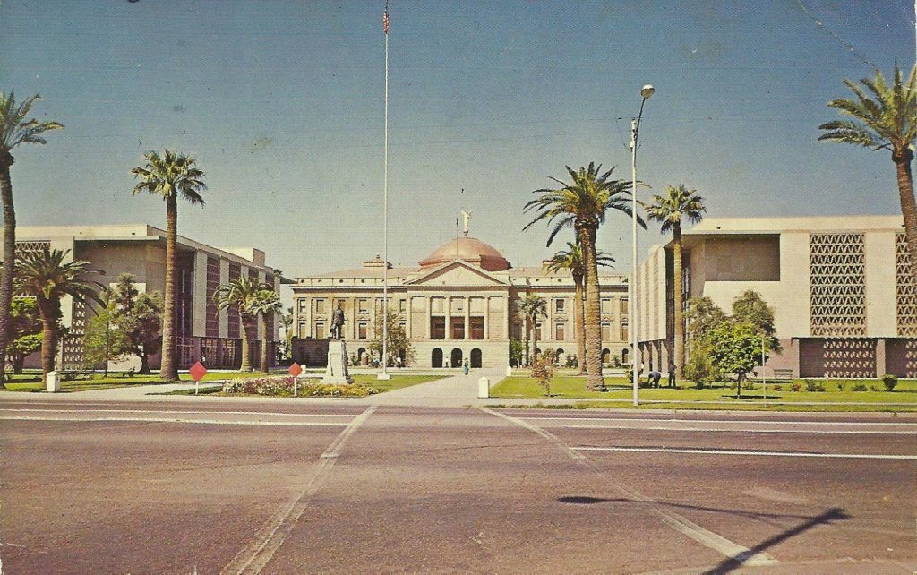
The capitol

The capitol

Capitol_1960s
The Capitol and legislative chambers in the 1960s, before the erection of the brutalist Executive Office Tower.

Channel 12's Brahm Resnik asked me to nominate the three most significant Arizona political events since statehood. It's a bit like wanting a cinephile to name only three favorite movies. I settled for 1) statehood, which was not a given when it happened; 2) The congressional delegation's ultimately successful decades-long pursuit of Colorado River water, and 3) SB 1070, which is a bright red marker for the hotbed of intolerance, ignorance, extremism and backwardness into which the state has descended. Other events could contend, such as Barry Goldwater's 1952 narrow victory over Sen. Ernest McFarland, marking the birth of the Republican Party's ascendancy.

One of the most telling political stories, however, doesn't concern politicians or elections, at least not directly. It's about the old capitol building. The copper-domed structure was actually built as the territorial capitol and completed in 1901. The architect was James Riely Gordon, who designed many court houses in Texas, as well as a grand one for Bergen County, N.J. Gordon set aside his usual Romanesque Revival style to create a territorial capitol made from native materials. It was originally intended to be much grander, but the territory cut back funding. Additions made in 1918 and 1938 preserved the Gordon design.

President Kennedy (perhaps apocryphally) quipped that it was the ugliest state capitol in America. This was certainly not true: The Alaska capitol resembles an insurance company office; the Ohio statehouse with its forever-incomplete dome defines homeliness and lack of proportion, and North Carolina's looks like the court house for a small, poor county. The only saving grace for New Mexico's building is that it is in Santa Fe. To me, the old Arizona capitol always held a certain modest grace, particularly when I was growing up and it dominated the vista at the foot of Washington Street. But it's also true, odd and perhaps telling that Montana, which still doesn't have 1 million people, has a much bigger, grander capitol. And otherwise poor, conservative states such as West Virginia, Arkansas and Mississippi boast majestically beautiful statehouses.

Halftime in Arizona

Note to national and international Rogue readers: As Arizona marks 100 years of statehood this month, you'll have to put up with more than the usual number of AZ- and Phoenix-centric posts.

AzSemiIn 1962, Arizona marked its 50th year as a state. It's a vivid memory for me, although I was but a child. I loved the commemorative seal with the cactus wren, so much more appealing than today's gaudy centennial emblem. Fifty years of statehood was a remarkable event for those still living who had witnessed statehood and lived in Arizona Territory, my grandmother among them. The state in 1962 had barely more than 1 million people, with Phoenix not yet at the half-million mark. Phoenix was becoming a big city with comforts unimagined 50 years before, especially air conditioning. Still, the frontier was close enough to touch, living history was all around and much of the state was still wilderness. Vast empty distances separated the settled areas and those were compact and clear in their purpose.

Prescott, for example, the onetime territorial capital, was an enchanting little town with appealing rough edges. None of today's sprawl existed. It had only recently lost its status as a division point on the Santa Fe Railway between Phoenix and Williams Jct. Mining and ranching were the economy. The highway up Yarnell Hill was notoriously treacherous. Flagstaff was a major railroad town, also depending on sawmills for the logging industry and Arizona State College. The Mogollon Rim was virtually uninhabited, just one of many parts of the state as wild as ever. The state highways were two lanes, taking you to rich history that wasn't across the street from a Wal-Mart. Even in Phoenix, you could see old cowboys, the real thing, living out their last years in the elegantly-designed-but-neglected old apartments that graced the neighborhood between Seventh Avenue and the capitol.

Central Avenue Part 2

Phoenix1

Midtown, including the Viad Tower, left, after the big boom.

The first defining event of today's Central Avenue was the real-estate boom of the late 1980s and early 1990s. With land from Fillmore Street to Camelback Road upzoned for skyscrapers and money flowing from the deregulated savings and loan industry, the city was remade by a huge real-estate boom. Stuck with the disjointed set of highrises outside the old central business district, the city tried to put planners lipstick on the pig in the 1970s by christening the area from the railroad tracks to Camelback and Seventh Avenue to Seventh Street as the Central Corridor. As I wrote in the previous post, the visionaries of the 1960s and 1970s imagined Central would become Phoenix's version of Wilshire Boulevard. That never happened. Phoenix lacked the economy, assets and ambition of Los Angeles. But it gave a big try in the '80s and '90s.

These were the years that saw the rise of the Dial Tower at Central and Palm Lane. It was the new headquarters of the old Greyhound Corp. and remains, with its distinct deodorant container shape and copper skin the only truly arresting skyscraper on Central. Two bank highrises were built just south of Osborn, along with a little World Trade Center-style tower at Virginia, displacing the Palms Theater, and a few midrises. USWest anchored one of two skyscrapers erected on the northeast corner of Central and Thomas, where the iconic Bob's Big Boy, beloved of cruisers, stood. But this was nothing compared with what was planned. Back in the 1960s, the idea of a monorail running down Central was floated. It was revived in the '80s as part of a developer's plan to build, north of Indian School, the tallest building in the country with the monorail connecting the mammoth skyscraper to Sky Harbor.

Central Avenue in old Phoenix

Central Avenue in old Phoenix

Central_ave_phoenix_AZ

Central and Monroe, around the year I was born (1956)

"The trouble with Central is that it isn't central to anything any more." So spoke a major leasing executive in 2000, over a breakfast I had been dragooned into to get my mind right about what had happened to my hometown. He was wrong. Central Avenue does much more than demarcate street numbers from east to west. It lies at the heart of a far-flung Valley metroplex. Central — original Center Street, renamed in 1910 — is the touchstone of Phoenix's history, with more stories than a hundred blog posts could tell. It remains the most interesting street in the city. And it will be the critical marker for a quality future, if the metropolitan area stands a chance of attaining one.

In the old city, Central connected the discrete parts that made Phoenix whole. Starting at South Mountain Park, the largest municipal park in the world, it crossed two-lane Baseline Road. In both directions spread out the enchanting Japanese Flower Gardens. Ahead were bands of farmland, pastures and citrus groves as it descended to the Salt River, with the skyline and far mountains arms-length clear in the distance.

After going through the tiny south Phoenix business district, you crossed one of two bridges over the river (Mill Avenue being the other). The 1911 Center Street Bridge ran 3,000 feet across the Salt River, included electric lamps, and was one of the town's proudest achievements. Before heading downtown, Central ran through neighborhoods and commercial strips.

For years, the colorful Central Liquidators was among the businesses south of the tracks. In the early days, both the Southern Pacific and Santa Fe railroads sited their depots on Central, before moving to the new Union Station at Fourth Avenue in the 1920s. Depression public works built an underpass that for decades held four very tight lanes. Before the overpasses at Seventh avenue and street, this was the only sure way under what were then busy rail lines. Everybody honked when they drove through the concrete tunnel.

Phoenix 101: Wallace and Ladmo

Wallace_and_ladmo

Lad Kwiatkowski, Pat McMahon and Bill Thompson.

I went to the Muppets movie over the weekend. It was all right. I never watched Sesame Street and the heyday of the Muppets television show was when I didn't even own a TV. In any event, I am a lost demographic to such benign stuff. I grew up in Phoenix, where we had Wallace and Ladmo.

Most children watched a clown show in their cities and towns. Not us. We were brought up on the very adult humor of the Wallace show, which ran from 1954 to 1989 on KPHO. The names changed, from It's Wallace? to Wallace & Company to the Wallace and Ladmo Show. What didn't change was the show's biting humor, satire and irony, along with classic slapstick and cartoons. For the rest of our lives all we could do was feel sorry for the children who were stunted by clown shows.

The regular cast featured Bill Thompson as Wallace, Lad Kwiatkowski as Ladmo and my friend Pat McMahon. Wallace, or Wall-Boy as Ladmo called him, was the host and butt of much humor. Ladmo was the everyman or everykid, full of fun and mischief. McMahon played a host of characters, many of which gave the show its bite. Among them was Gerald the brat, the nephew of the TV station's general manager; Aunt Maud, the doddering, bad driver old coot from Sun City; biker Bobby Joe Trouble; Captain Super, a parody of assorted super heroes, and Boffo the Clown, who hated children.

Sky Harbor

Sky Harbor

SkyHarbor_oldtower

I was always a child of the railroads, so Union Station held much more magnetism for me than the airport. Still, in the 1960s, Sky Harbor was a sweet little airport. It had a romantic name. The old blond-brick West Terminal and tiny control tower hearkened back to aviation's infancy — it had only been six decades since the Wright Brothers' first powered flight.

You boarded by stairs — jetways were several years off. The new East Terminal was graced by a dramatic mural of Phoenix's founding myth and flight science above the airy modern waiting room. It also had a second-story observation deck, where one could watch the airplanes, complete with telescopes. Our Cub Scout den was given a tour of the control tower. All this was before hijackings and the rise of the present Security State.

It was a beautiful airport with a certain '50s charm. One reached it from 24th Street along grassy parkways with trees. And back then, the route into downtown was still lined with pleasant motels and "auto courts," all human scale.

Sky Harbor had two runways, which were plenty back then. On the south edge was the Air National Guard midair refueling tanker wing (Richard Nixon gave a campaign speech in the big hangar during the 1972 campaign).

On the north side, beyond the general aviation hangars, were the Southern Pacific tracks, which carried three passenger trains a day in each direction. The best airplane watching was on 40th Street, which was a two-lane affair that dipped into the riverbed and marked the east boundary of the airport. The 727s and 707s came in right overhead.

Airlines were highly regulated. Hubs were far in the future. So regional players such as Bonanza, Hughes AirWest and Western were as important as United, American and Continental. I made my first airplane flight from LA to Phoenix when I was ten (we had gone there on the Sunset Limited, by far the more enchanting journey for me). Flying was special then. People dressed up. Airlines treated you very well. There were no cattle calls or lines from LockUp.

South Phoenix

South Phoenix

JGardens
South Phoenix encompasses so much history, so many cultures and distinct districts, it deserves more than one post. Every square mile is special. Still, a start. It's not a separate city such as South Tucson, so I'll go with the style "south Phoenix." When I hear the words "urban village," I reach for my Colt Python plus Speedloaders, so forget about the city's developer-speak term "South Mountain Village."

Then there's the matter of geography. For many Anglo Phoenicians, when the city still had some cohesion, "south Phoenix" began at the Southern Pacific tracks. This was, and latently remains, a place where "the other side of the tracks" is a powerful totem (it helped do in the unfortunately named Bentley Projects, the galleries, bookstore and cafe). A subset of "south Phoenix" emerged in the 1960s, to define everything below the somber wall of the Maricopa Freeway. And true south Phoenix is south of the Salt River. All must be dealt with.*

Phoenix's relatively small Mexican-American and African-American populations were historically located south of the tracks. Well into the 1970s, the commonplace offensive term for the latter was used by whites. Schools were segregated and inferior. Poverty and injustice were severe. Corruption by city officials legendary, at least through the 1940s. Most property ownership was controlled by deed covenants that largely excluded minorities (I told you this was a Southern town). Ownership was more possible south of the river, and minorities gathered there. (Most of the city's legendary and now largely lost barrios were north of the Salt, but a few, such as the River Bottom, were in south Phoenix proper). Minorities were also heavily employed as agricultural labor. This was farm country, especially after the completion of the Highline and Western canals by 1913.

The most successful farmers were the Japanese, who arrived early in the 20th century and were able to purchase farms in the 1930s, after Arizona's anti-"Yellow Peril" law was found unconstitutional. Arizonans my age remember them for the stunning Japanese Flower Gardens that ran for miles along Baseline Road. But the Japanese were among the most innovative growers, raising a variety of crops. This also raised much jealousy among Anglo farmers, who were happy to see them, including American citizens, interned during World War II. After this shameful episode, the Japanese, including many of their sons who had fought in the U.S. Army, returned to south Phoenix and farmed again.

Cold War memories

Cold War memories

Civil Defense map (1)

In Arizona, Tucson shouldered the most dangerous part of the nuclear standoff between the United States and the Soviet Union. Some seventeen Titan II intercontinental ballistic missiles ringed the Old Pueblo from 1963 to 1982 in blast-hardened silos (one still exists as a museum near Sahuarita).

The silos wouldn't have been enough to protect the ICBMs from the many incoming nuclear warheads targeted by the USSR, especially as the Soviets gained parity with the United States in missiles and warheads. So facing a launch warning, a president would have had minutes to get the Titan IIs, which carried the largest U.S. warheads, airborne. Tucson would have been engulfed in a firestorm of hydrogen bombs. The motto of the Strategic Air Command, on display at the gates of bases such as Davis-Monthan, was "Peace is Our Profession."

Still, Phoenix was an important secondary target during much of the Cold War. In addition to two Air Force bases used primarily for fighter-jet training (Luke and Williams), the city had a relatively large set of valuable aerospace and technology plants, plus research operations. It was the state capital. And, had "the balloon gone up" in such a way that city-for-city targeting happened, Phoenix was a major population center. It was highly vulnerable. As one of my mother's water engineer friends said, "Bomb the dams and it's all over." The evacuation plans drawn up by Civil Defense for American cities in the 1950s wouldn't have worked: Where would you send half a million souls in an isolated place largely surrounded by desert?

Even in a limited nuclear exchange, Phoenix would have been vulnerable to fallout. It was badly lacking in fallout shelter space (I remember seeing a report in the early 1970s that, as I recall, claimed space for about 100,000 when the metro area held six or seven times that number). Still, the ubiquitous shelter signs were everywhere downtown: The round older ones in red-white-and-blue with CD (Civil Defense) emblazoned on them, the more spare "Fallout Shelter" black-and-gold rectangles from the '60s. (One of the old ones was on a lamp post near First Watch downtown well into the 2000s; I hope somebody preserves it).

These were mostly basements of office buildings, stocked with food and water by the feds, meant to protect against radioactive fallout. I remember one in the utility tunnels under Coronado High School; when I went down there in the '70s, the food, water and geiger counters were all neatly packed, a decade old. Yet these were not blast shelters. Few Phoenix houses had even basements. Few Phoenicians dug their own shelters.

How malls remade old Phoenix

How malls remade old Phoenix

Park_Central_Shopping_City_parking_lot_1950sSing a city of malls. Actually, the first modern mall west of the Mississippi was built in Dallas and the first suburban mall was Northgate in Seattle (now closed and turning into a dense development around light rail). But it's easy to imagine Phoenix invented them. They were not good for those of us who loved shopping at the great stores downtown, and how they contributed to the central core's collapse.  But most Phoenicians loved them.

When I write "mall," I don't mean the beautiful 19th century Arcade in downtown Dayton. I mean a shopping complex built around the automobile. Park Central was Phoenix's first, developed by the Burgbacher brothers on the site of the former Central Dairy and opening in 1957. It was anchored by Diamond's, Newberry's and Goldwater's, the latter closing its downtown store two miles south and beginning the end of downtown retail.

Even so, in the early- and mid-1960s, downtown held its own as the state's busiest shopping destination — but the die was cast. Most natives don't even remember when Phoenix was more than a city of malls.

I grew up within bicycle distance of Park Central (had my bike stolen there, too). It was open air (the city was not yet devastated by the heat island), convenient and wildly popular. It anchored Midtown, along with the twin towers across the street, the taller of which sported an outside glass elevator and the shorter being home to the Playboy Club. Old Park Central was semi-urban, contiguous to the city and human-scaled.

It was followed by Biltmore Fashion Square, which until Westcor turned it into another lookalike suburban soul-killer, was also open air, with plenty of shade and in a pleasing scale. Across the street was the open-air Town and Country shopping center (which was not an empty name, for the city around it was still meshed with citrus groves and horse properties). Chris-Town became the first enclosed, air-conditioned mall in 1961 — the property has been a farm owned by the Chris family.

The Deuce in old Phoenix

The Deuce in old Phoenix

Mikes_Cafe_Washington_3rd_St_1966

Madison st james copyThe block of shuttered buildings (right) just west of the Suns arena was, by the 2000s, almost all that was left of the storied Deuce, Phoenix's skid row. It has since been leveled, losing two historic hotels, so team owner Robert Sarver could make another holy surface parking lot.

In its heyday, from the 1920s through the 1970s, the Deuce extended over several blocks from the Southern Pacific tracks to Van Buren, centered along Second Street. It's open to debate as to whether Second Street was the origin of the name. Or if it was a shortened version of the Produce District, the warehouses and loading docks clustered along the railroad tracks, including middle-of-the-street spur lines that ran along Jackson and Madison. Yet another interpretation: The area was Beat 2 of the Phoenix Police and the cops nicknamed it.

However it came by its moniker, the Deuce was one of the city's most colorful and storied districts. During Prohibition, it was known for its speakeasies. For decades, brothels and gambling could be found along the infamous Paris Alley, off Second Street between Jefferson and Washington.

Old downtown Phoenix was remarkably compact and walkable. The main part of the central business district ran along Central and west to Seventh Avenue. East along Washington and Jefferson were a remarkable variety of stores, including Penney's and Korrick's department stores, as well as the Fox Theater, the barber college, Dr. Pease Dentist and Dr. Hugh Ilstrip's chiropractic practice.

The Greyhound and Continental Trailways bus depots faced each other at First Street and Van Buren. East of Greyhound was the Arizona Republic/Phoenix Gazatte building, St. Mary's church and the church schools, and Phoenix Union High School. South of this, the Deuce.

It was a dense mix of single-story business buildings and two- to five-story single-room occupancy hotels, many dating back to territorial days. One could walk into this "bad part of town" by taking a few steps east of the Fox or south of St. Mary's. The small businesses there ran the gamut from bars, cafes, package-liquor shops, gospel missions and pawn shops to second-hand furniture outlets and an Army-Navy surplus store. Franco's America Bakery was at Fourth Street and Washington. It was next to a Western wear store with a lifesize horse standing on the overhang. The Matador Mexican restaurant was in the Deuce before it was relocated to a location on Adams. A few houses survived in the district, as well.

The remains of the city's Chinatown were part of the Deuce (although the Chinese, not facing the discrimination they had suffered in California, followed the Anglos out as the city sprawled). Sing High Chop Suey House, now moved a few blocks west of the Deuce, is a survivor. And then, starting at Madison, the produce operations such as Central Wholesale Terminal and United Produce.

The most famous denizen of the Deuce was Ernesto Miranda, who worked off and on at United Produce. Miranda was arrested in 1963 for kidnapping and rape, and gave a confession without having a lawyer available during the interrogation. The conviction was thrown out by the Supreme Court and police agencies were forced to routinely "Mirandize" suspects. Still, Miranda himself was convicted in a second trial, where the tainted confession was not introduced, and served time. Released in 1972, he returned to the Deuce where he sold autographed Miranda warning cards. In 1976, he was fatally knifed at La Amapola bar, located at Second Street and Madison. By that time I was working on the ambulance, but was off-duty that night; a crew from B-Shift transported Miranda to Good Samaritan Hospital where he was pronounced dead.

Phoenix 101: The East Valley

Phoenix 101: The East Valley

Chandler_neighborhood

A subdivision in Chandler.

Of all the many delusional linguistic constructs in metro Phoenix meant to sell real estate and sustain the unsustainable (think, "The Sun Corridor," "the North Valley," etc.), only the East Valley has the most substance to it. Such was not always the case.

In 1960, when Phoenix's population was 439,170, Mesa clocked in at a mere 33,772. Tempe was a little college town. Scottsdale a small artist's colony/former farm town with "Western" touristy schlock. Chandler was a stop on the railroad for the San Marcos Hotel. The remainder were tiny agricultural villages. All were separated by miles of fields, groves, and history.

Mesa, for example, was distinctive for its settlement by Mormon pioneers. Tempe was the home of the normal school turned Arizona State College and just renamed a university. All the real towns supported separate newspapers. Mesa and Tempe had their own street-grid numbering systems. Guadalupe was its own unique enclave, first settled by Yaqui Indians fleeing the Mexican Revolution and was the most culturally Mexican place in the Salt River Valley.

The common denominators: Economies based on agriculture, the Southern Pacific Railroad, and (with the exception of Scottsdale) being south of the Salt River and thus part of the coalition that fought against Phoenix and north-bank farmers for water rights and allocations before and after the Newlands Act. Power in the area resided with the big growers and prosperous businessmen of Mesa, all members of the Church of Jesus Christ of Latter-day Saints.

By the late 1970s, the landscape was changing fast. Phoenix, Scottsdale, Tempe and Mesa had grown together. The Superstition Freeway was being slowly built east from I-10, reaching Dobson Road around 1977, disrupting and slowly killing the rich cluster of local businesses that lined old U.S. 60 along Mill Avenue, Apache Boulevard and Main Street.

Mesa's population was closing in on 150,000, and it was annexing miles of retiree trailer courts that ran along Main toward the Pinal County line. Samaritan Health Services, the forerunner of Banner Health, opened a new hospital, Desert Samaritan, near the new freeway. ASU had grown to be a large university and Tempe extended south with The Lakes. The first subdivisions of something called Ahwatukee were being finished. From the rise of I-10 at Baseline, the view east glittered like a jewel at night. Still, miles of citrus groves ran east of central Mesa, centered around Val Vista.

Almost everything south of central Mesa and Tempe was still agriculture. Chandler was a small town and Gilbert little more than a crossroads. Williams Air Force Base was in operation and far from everything, linked by the ubiquitous two-lane concrete roads lined on each side by irrigation ditches.

The next two decades would see startling change, and the evolution into a true separate identity within the Phoenix metropolitan area.

Phoenix 101: ‘The Valley’

Phoenix 101: ‘The Valley’

Phoenix night skyline

Growing up in the Phoenix of the 1960s, "the Valley" was a benign term. It either meant the Valley of the Sun, the touristy moniker of the booster class, or the Salt River Valley, where Phoenix was geographically centered. The city was large and powerful, both economically and politically. The suburbs were small and inconsequential, most just still farm towns or railroad sidings.

Indeed, old Phoenix, central and south Scottsdale, Tempe and old Mesa sit in a real valley. The ancient Salt River Valley dips between the South Mountains (or, on old maps, the Salt River Mountains) and the Phoenix mountains, such as Shaw Butte, North Mountain, Piestewa Peak and Camelback. One could once see this on spectacular display coming north on Interstate 10 as it crossed Baseline Road, or from Baseline and the Japanese Gardens. For much of the early decades of settlement, this posed major flood-control problems. Rains cascaded off the mountains in search of home in the meandering, fickle Salt River. Nineteenth Avenue would become a river flowing down to the capitol before construction of Cave Creek Dam. At flood stage, Indian Bend Wash cut Scottsdale in half well into the 1980s. That same river, carrying rich deposits of soil from upsteam, created one of the world's great alluvial valleys here, custom made for farming that sustained two civilizations.  So whether for tourists or as a geographical reality, "the Valley" was a widely used shorthand, harmless and endearing, often the sign of a native. It was part of the name of the most powerful bank. But there was no doubting this was Phoenix, or, as some called it, Greater Phoenix.

When I returned, the old connotations had changed. "The Valley" was widely used as the proper name of metropolitan Phoenix. This was abetted by the media, including the most influential, The Arizona Republic (the old Phoenix Gazette having been closed; too bad, imagine if it were an online newspaper with an entirely different tone and coverage focus than the big ship). This same media often didn't know where downtown Phoenix was — so many times I heard a radio or television report of some news "downtown," at, say, 24th Street and Camelback Road. I suppose it was a combination of ignorance and an effort at new-style marketing. Hence, we don't have the Phoenix Cardinals or Phoenix Diamondbacks, as most cities do, but "Arizona," which sounds like a college team. And it was an attempt to pander to suburbs that had grown to elephantine population sizes.

A Phoenician’s take on Tucson

800px-Ronstadt_house_6th_Avenue_Tucson_from_SE_1

The Ronstadt house on Sixth Avenue in Tucson.

Early in the 20th century, Phoenix surpassed Tucson in population and never looked back. The old joke: Tucson hates Phoenix and Phoenix doesn't pay any attention to Tucson, which makes the Old Pueblo hate Phoenix even more. I don't claim to be a Tucson expert, but a reader new to the city asked to learn more. So what follows is a Phoenician's idiosyncratic take on Arizona's second city.

Tucson is much older than Phoenix, having been founded by the Spanish (led by an Irishman in the pay of the Spanish crown) in 1775, a tenuous foothold in Apache country. It was a part of Mexico until the Gadsden Purchase of 1853 (otherwise, the border would have been as close as Goodyear — how'd that sit with the white-right Midwesterners?). Thus, Tucson always wore its Hispanic side with ease and pride. Tucson got the first main line of the Southern Pacific Railroad in the late 1880s and for decades was the most populous city in the territory and young state. It was also a bastion of the Democratic Party, long after the state as a whole turned Republican. This was Mo Udall, Dennis DeConcini and Raul Castro country.

Growing up as a child of the Cold War, I knew Tucson would be a first-strike target in a "counterforce" nuclear exchange, because of the Titan II missile silos that surrounded the city. My first visits were on the train. My mother and I would board the remains of the once-grand Imperial, now a mail train with one coach, at Union Station, and travel south. We would spend the day in downtown Tucson and take the still crack Sunset Limited back home that evening. Early memories: The Santa Catalinas towered over the city in a way no mountains did Phoenix. Tucson was dry, a desert city, so different from the (then) lush oasis of Phoenix. Downtown was busy and vibrant, but no more so than Phoenix. I wasn't impressed.

Phoenix 101: The Phoenix 40

Phoenix 101: The Phoenix 40

Once upon a time, the Phoenix 40 ran this town, got things done, showed real leadership. The Phoenix 40 was an exclusionary bunch of powerful white men trying to hold onto their power in changing times. The Phoenix 40 was only the tip of an iceberg of evil and corruption that sits deep in the DNA of the city and state. So go the tales, myths and realities long after the legendary group morphed into the benign and toothless Greater Phoenix Leadership.

PulliamThe real Phoenix 40 was formed in 1974 by Arizona Republic publisher Eugene Pulliam (left), lawyer-civic leader Frank Snell and KOOL owner Tom Chauncey. They sent a letter to prospective members and 40 leaders, including Gov. Raul Castro, showed up at the Biltmore for the first meeting in early 1975. The group hoped to focus on transportation, crime and education — crime getting top billing after the murder of a key witness in the land-fraud trial of Ned Warren Sr. The original membership is no secret, not quite 40, and reads like a Who's Who of mid-1970s Phoenix: Clarke Bean, Hayes Caldwell, Chauncey, Msgr. Robert Donohoe, Junius Driggs, Karl Eller, George Getz, Sherman Hazeltine, Robert Johnson, George Leonard, Stephen Levy, James Maher, Richard Mallery, Samuel Mardian, Jr., James Mayer, Rod McMullin, Loyal Meek, Dennis Mitchem, Pat Murphy, Rev. Culver Nelson, William Orr, Jesse Owens, Pulliam, William Reilly Sr., Newton Rosenzweig, Raymond Shaffer, Bill Shover, James Simmons, Paul Singer, Lawson Smith, Snell, Franz Talley, Thomas Tang, Maurice Tanner, Keith Turley, Mason Walsh, Robert Williams and Russell Williams.

And, yes, it's telling that the list didn't include, say, Lincoln Ragsdale or Rosendo Gutierrez. Yet the Phoenix 40 was never as dangerous as its critics feared nor as benign as it claimed to be, but it's an important touchstone in the city's evolution to the current unpleasantness.

Encanto Park in old Phoenix

Encanto Park in old Phoenix

Encanto_Park_Phoenix_Corporate_Center_Mayer_Central_Plaza_1960s(1)

A city such as Cincinnati built great parks, from the showpiece Eden Park, home to the Cincinnati Playhouse, Cincinnati Art Museum, Kron Conservatory and Mirror Lake Fountain, to the exquisitely designed Ault Park near the tony Mount Lookout and Hyde Park neighborhoods. Eastsiders who won't venture beyond the "Sauerkraut Curtain" may not even know about Mt. Echo Park, one of my favorites with its awesome views of downtown and the Ohio River.

The Queen City of the West had the good fortune to come of age in the golden age of park design and have the wealth to pull it off. Phoenix, a modest farm town at this time, built only one: Encanto. That makes it all the more a civic treasure. This Saturday Encanto Park will celebrate its 75th anniversary.

I write this not to take away from the city's achievement with desert parks, especially South Mountain Park and Papago Park. But they are what they are, often stunning preserves of the Sonoran Desert for hardy hikers and, more often, drivers.

Encanto was different, built as an oasis of shade and grass and City Beautiful Movement design, meant for people, picnics and strolling. Now more than ever, you can feel the instant cooling of the park and golf courses when you drive south of Thomas on 15th Avenue on a summer night. It's not like the Midwest — for that kind of lush greenery, look to Cincinnati. It lacks the size and resources that Los Angeles could put into Griffith Park. Encanto, inspired by San Diego's grand Balboa Park, is its own enchanted feat. It is a capsule of old Phoenix, a magical refutation of those who say "Phoenix has no soul."