Barry Goldwater

Barry Goldwater

Barry_at_31_1940

Barry Goldwater in 1941.

Phoenix would benefit from some heroic statues to enrich the downtown streetscape. It's not as if we're lacking in heroes and audacious history. Instead, we get a bronze of Barry Goldwater in Paradise Valley, unreachable by pedestrians but with an adjacent parking lot. Then there's terminal four at Sky Harbor named after Goldwater. And a street in Scottsdale. A newcomer might think the only history worth remembering, if badly painted, concerns the long-serving senator and 1964 presidential candidate.

Readers of this blog know better. But understanding Goldwater's place in Arizona is a daunting challenge. The magisterial biography remains to be written. And for most of his public career, Goldwater was a national figure. We must also contend with a good deal of nostalgia and hagiography concerning the hero. An example of the latter was a recent article in National Review about how Barry was a leader in Phoenix's school desegregation before the Brown decision. The former goes something like this: Barry was no Kook, he fought the religious right and one shouldn't conflate today's conservatism with that of Goldwater. Even I have been guilty. But the reality is more complex and interesting.

Why they came

Why they came

Washington&Central

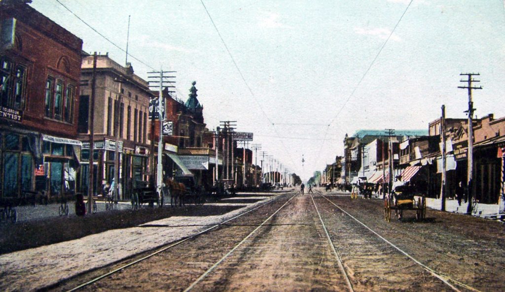
Washington Street in Phoenix, 1890. The trees and adobe buildings of 1870 were mostly gone from this view.

My grandmother, Sarah Ella Darrow, was born in 1889 in the Chickasaw Nation, Cumberland, Indian Territory. Her parents had come to I.T., as the postal address read for today's eastern Oklahoma, as Presbyterian missionaries. Then they ran a small store.

Earlier, on the Texas frontier, her mother (my great-grandmother), Emma Caroline Hulse, had been scalped as a baby during a Comanche attack after troops were withdrawn for the Civil War — she survived and went on to marry my great-grandfather, Francis Marion Darrow who hailed from the Midwest.

Indian Territory, home of the Five Civilized Tribes, was fine country for farming and timber, well watered, with growing towns and new railroads. But whites couldn't own land and that was Darrow's dream. The Chickasaw governor (chief) loved my great-grandfather and wanted to adopt him (thus putting him on "the rolls" as a tribal member), but Darrow declined. Then the store and their home were destroyed by a tornado, with one daughter killed.

They went west, to Arizona, to the Salt River Valley. They and hundreds like them came for relatively cheap land and good farming. Like much of the West, Phoenix was heavily publicized to draw settlers. One thing was even true: This was one of the world's great alluvial valleys, fanning out in mostly flat, irrigable land from a river that flowed year-round, or so it seemed.

Here the Hohokam had created the most advanced irrigation system in the New World, with at least 200 miles of canals, before that civilization faded. The Pima, likely the descendants of the Hohokam, had moved south to the Gila River and beyond, partly to escape raids by the Apache.

In the late 1850s, Charles Trumbull Hayden noticed this vast, mysterious valley with its tree-lined river while hauling freight to Tucson. He would be back. He would name his son Carl.

By the 1890s, the phoenix was stirring from the ashes. The Apache had been subdued by the U.S. Cavalry. Thousands of acres were under cultivation, especially for wheat, barley and fruit trees. Anything would grow in this soil, provided water was added. The project of clearing out and extending the old Hohokam Canals was well along by then. Phoenix as a settlement was more than 20 years old.

The first railroad had arrived on Independence Day, 1887. In 1890, the Census Bureau declared the American frontier closed. By the time my family arrived, the chance to start fresh and live the Jeffersonian dream of yeoman farmer was fading most places. Not here.

Eddie Basha, an appreciation

Eddie Basha, an appreciation

Bashas

Editor's Note: Eddie Basha, the last of the hometown merchant princes, died last week at age 75. The following article was originally published in 2008 but captures Basha well.

By Jack L. August, Guest Rogue

I answered the cell phone as I headed north on I-17 en route to Prescott. "This is Raul Lopez," the caller said in a heavy accent, "and I saw you on that Channel 8 program Horizon last night, Dr. August." Not knowing the caller I mumbled something about the then-host Michael Grant, but was interrupted with a string of criticisms about my discussion of former senators Carl Hayden, Barry Goldwater and Dennis DeConcini and, to add insult to injury, Mr. Lopez offered, "I don't like that moustache either." I tried to recover but the mystery called moved forward without pause: "The Haydens, Goldwaters and DeCincinis were not responsible for Arizona's growth and development but instead," he continued, "the miners and laborers in the copper mines of Morenci, Miami and Globe, should receive a lot more credit than those three politicians." He was contentious and irritated and I tried to find a diplomatic way to diffuse the situation. This Lopez character, though, seemed unbalanced and out to insult me at any cost.

He then said I could afford to lose a couple pounds and told me to wear a blue shirt and red tie the next time I was on television because what I wore that night had hurt his eyes. Finally, I exploded, asked him for his location, because I was going to turn around, head back to Phoenix, and confront him. I was furious and angrily terminated the call after hurling a few pejoratives of my own. The mystery tormentor tried three more times to call back but I refused to answer. Later, after I arrived in Prescott, I listened to my voice messages and heard, "Geez, Jack, this is Eddie Basha. I didn't mean to piss you off." He got me. I was the next in a long line of innocents caught in the Eddie Basha world of phone pranks.

What killed downtown, Part III

What killed downtown, Part III

Coffee_shop01

Central and Van Buren circa 1971. This once-vibrant business block is about to be replaced with Valley Center (now the Chase Tower). The old Trailways bus depot that stood at the far left has already been demolished.

Part I and Part II of "What Killed Downtown Phoenix" were the most popular posts in the history of Rogue Columnist. So much for the notion that Phoenicians don't care about the center city. Now it's time to bring the story to a conclusion.

By the mid-1970s, downtown was in a freefall, despite the construction of the Phoenix Civic Plaza, Hyatt Regency, new Hotel Adams, new Greyhound bus depot and skyscrapers housing the headquarters of the state's three big banks.

Unfortunately, in the process many historic buildings were demolished, including a priceless red sandstone multi-story building at Second Avenue and Washington. Block-long parking garages and assembly of superblocks created long, empty spaces along sidewalks where once there were dozens of shops.

Several valuable territorial-era structures were demolished to create the desolate, sunblasted Patriots Square (workers discovered an "underground city" from frontier Phoenix that had housed opium dens and gambling parlors, protected from the heat in an era before air conditioning). These and others lost were precisely the kind of buildings rehabbed in downtown Denver into Larimer Square.

FoxTheaterOne of the greatest calamities was the demolition of the Fox Theater, the finest movie palace downtown. This happened without a peep of protest. On the land, the city built a "transit center," which was little more than a Maryvale-style ranch house "station" and parking stalls for city buses. The Paramount somehow survived, running Spanish-language films (it would be reclaimed as the Orpheum). Another calamity was the Westward Ho, which closed as a hotel and only avoided the wrecking ball by being turned into Section 8 housing. The smaller San Carlos, thankfully, was saved as a historic hotel.

What killed downtown, Part II

What killed downtown, Part II

Washington_2ndSt_PHX_1958

Downtown was still busy in the late 1950s, at Third Street and Washington. Even though this was part of the Deuce, note the variety of businesses and pedestrians.

In the previous post, we left downtown Phoenix in 1940 as the vibrant business and commercial center of a small, relatively dense city, surrounded by pleasant neighborhoods, served by streetcars, and dependent on agriculture. World War II brought massive changes to the Salt River Valley. Thousands of troops were trained here. Phoenix was still a frontier town, wide open to gambling and prostitution, and governed by a shady city commission. At one point, base commanders declared the city off limits to troops. This began a reform movement that eventually led to a council-manager form of government and the decades of "businessmen's government" from the Charter movement.

The Battle of Britain and the threat of strategic bombing made a deep impression on American war planners. So in addition to wanting to move plants away from the vulnerable coasts, they also widely dispersed new war industries and Army Air Forces bases around the valley. One example was the Reynolds Aluminum extrusion plant built at 35th Avenue and Van Buren, far from the city center. Dispersal brought the first Motorola facility, but not to the central business district. This set in place a habit of decentralization that continued after the war when city fathers set out to bring new "clean industries" to the city. They failed to land a Glenn Martin Co. guided missile venture for the vacant Goodyear plant in its namesake town. But Goodyear returned in 1950, eventually building airframe components there. Garrett's AiResearch, which also had a plant outside the city during the war, returned after a vigorous Chamber of Commerce effort, to a site near Sky Harbor. No thought appears to have been given to locating the city's new industries near the core.

After the war, America embarked on a massive economic expansion and migration, both benefiting Phoenix. Demand had been pent up from both the Depression and wartime rationing. By 1950, Phoenix entered the list of the 100 most populous cities, at No. 99, with 106,818 in 17 square miles. Many servicemen who had trained here fell in love with the place and moved back as civilians. Inexpensive evaporative cooling became widely available and was installed in every house built in far-flung subdivisions.

What killed downtown, Part I

What killed downtown, Part I

Downtown_1930s

Downtown Phoenix in the 1930s, a view facing south.

When you see downtown Phoenix today, be kind. No other major city suffered the combination of bad luck, poor timing, lack of planning, vision and moneyed stewards, as well as outright civic vandalism. The only thing missing was a race riot, which happened elsewhere in the city during World War II and is not spoken about.

First, definitions. Downtown Phoenix runs from the railroad tracks to Fillmore and between Seventh Street and Seventh Avenue. Any other definition — even though much of the local media are oblivious to this — is ahistorical, inaccurate and, as my sister-in-law would say, just wrong. Twenty-fourth Street and Camelback is not downtown. Central and Clarendon is not downtown.

If one were going to site the center of Phoenix today, one would pick Arcadia, with majestic Camelback Mountain nearby. But that was not the case with the original township in the 1870s. The town was centered in the great, fertile Salt River Valley, soon to be reclaimed by revolutionary waterworks from the Newlands Act and connected by railroads to the nation. It was here that downtown grew and for decades flourished. But Phoenix was small and isolated. It did not grow from 10,000 in 1910 to more than 185,000 in 1930 like Oklahoma City. In 1930, Seattle's population was more than 386,000 and Denver nearly 288,000. Phoenix held 48,118 souls in the same year and was far from any other metropolitan area.

It's a fascinating counterfactual to wonder what might have happened in downtown Phoenix if not for the Great Depression and World War II. The decades before 1940 were the golden age of American city building, including art deco architecture and the City Beautiful movement. One can see it in such buildings as the Luhrs Tower and Luhrs Building, the Professional Building and the Orpheum Lofts (and, north of downtown, in the Portland Parkway). Conventional wisdom holds that the Depression didn't hurt Phoenix much, but this is not true. With deflation and little building happening, it stopped downtown dead. This was continued by the material shortages of World War II. By the time the economy began the long post-war expansion, downtown was facing too many obstacles and didn't have many of the grand bones of the other cities I mentioned.

Old Phoenix at night

Old Phoenix at night

Helsings
Helsing's Restaurant, designed by architect John Sing Tang, at Central and Osborn.

Coffee_shop_24_Hr_Central_Van_Buren_1970sThe other night an Arizona Republic reporter tweeted desperately for a 24-hour coffee shop in downtown Phoenix. He was out of luck (somebody suggested a donut shop around 24th Street and Thomas, a common lack of understanding about where downtown Phoenix is located; the closest place was the IHop on Central in Midtown). This was not always the case. One (left) was located at Central and Van Buren, near the Trailways and Greyhound bus depots, with a lighted billboard on the roof. It survived until around 1970, when it was torn down for Valley Center, now the Chase Tower.

Across the street, on the northeast corner, was Jay's Coffee Shop, also 24 hours. After it was torn down in the '70s, the resulting surface parking lot was vacant for decades. Yet another favorite was the Busy Bee on Washington Street, one of the many Greek-owned establishments, which lasted until being bulldozed for Patriot's Square. These were not hipster hangouts with free wifi, but the old-fashioned coffee-shops-as-restaurants.

Beyond downtown proper, a number of center city late-night and 24-hour establishments were hopping well into the late 1970s. These included two Helsing's on Central, Village Inn at Seventh Street and Monte Vista, Shaefer's on McDowell at Seventh Street, and Denny's at Van Buren and Seventh Avenue. A bit farther west was Brookshire's at 16th Street and McDowell. They were life-savers when I worked on the ambulance and we might not get dinner until three a.m.

Bob's Big Boy anchored the corner of Central and Thomas and was the magnet for participants of weekend cruising on Central. Other popular chains were Hobo Joe's (with the hoho statue out front), Googies and Sambo's (a Sambo's building on McDowell across from the Phoenix Art Museum still stands, most recently a Thai restaurant). Helsing's and some of the others were works of art, but none still stand, unlike a few of their preserved sisters in Los Angeles.

Old Phoenix was not an all-night town. Which is not to say it wasn't a late-night town.

Phoenix in the sixties

Phoenix in the sixties

Municipal_Building_1964
Downtown in the mid-1960s, with the new Municipal Building, forefront, and the iconic rotating Valley National Bank sign in the upper right.

Decades are arbitrary things. One could make the case that "the sixties" in Phoenix ran from the late 1950s through the early 1970s. In any case, it was a most consequential time, arguably the decade when Phoenix set the pattern for what it would become, for better and for worse. In the 1960 Census, Phoenix's population was 439,170, making it the 29th largest city in America and 187 square miles within the city limits.

This was a startling jump from ten years before, ranked 99th with 106,818 people within 17.1 square miles. Phoenix had quickly become a big city, but unlike most others: single-story, spread out, car-dependent and populated by few natives. It had decisively surpassed El Paso as the dominant city of the Southwest. Yet, as it remains today, its power was like that of a small town.

Nineteen-sixty saw the unveiling of the Wilbur Smith & Associates freeway plan. Although its closest big-city neighbor was Los Angeles, Phoenix had only one baby freeway, Black Canyon. Over the decade, this would curve into the Maricopa Freeway but otherwise the Smith plan was mired in controversy. Phoenicians didn't want to become another LA. The Valley Beautiful Citizens Council worried that freeways would destroy an already ailing downtown. A hundred-foot high Papago Freeway with "helicoils" provoked more opposition. In the end, almost all of the 1960 plan was adopted. But surface streets carried most traffic during this era.

Downtown retail was slowly dying, as was the dense corridor on McDowell between 12th Street and 18th Street called "the Miracle Mile." This included the lush, stately Good Samaritan Hospital campus, replaced 20 years later by the brutal spaceship building that remains today. Malls were flourishing, including Park Central, Tower Plaza, Thomas Mall and Chris-Town, named after farmer Chris Harri on whose land it was built. Many of the downtown merchant princes were dead or ailing. Others, notably Goldwater's (sold to Associated Dry Goods in 1963), moved to the malls.

Phoenix 101: Lost

Penn_Station1

The main waiting room of New York's Pennsylvania Station, shortly before it was demolished in 1963.

The effort to save the David and Gladys Wright House has become a cause célèbre, or as much of one that can find traction in the sprawling, just-rolled-in-from-Minnesota "civic" climate of metro Phoenix. A Facebook page has been set up. The New York Times flew in architecture critic Michael Kimmelman to write an appreciation of this Frank Lloyd Wright work, including such details omitted by the local media as the demolition company (!) being the one who realized the treasure they had been engaged to rip down and going to the city. The odds of success are long. Perhaps if this were the Joe Arpaio House and it was being torn down to create a day labor center for illegal immigrants. Otherwise, only the Resistance and minority of Resistance-minded citizens have a clue.

The modern preservation movement in America is often traced to the 1963 destruction of Pennsylvania Station, the classically-inspired masterwork of McKim, Mead and White in New York City. It was replaced by a brutalist Madison Square Garden with the railroad station in rat-passages underneath. New York has never gotten over this loss, nor should it. But it ensured that thousands of buildings nationwide were saved, including Grand Central Terminal. This never happened in Phoenix, yet it's not because we wanted for something grand like Pennsylvania Station to be destroyed by barbarians.

The Japanese Flower Gardens was one of our Pennsylvania Stations, a breathtaking Eden at the foot of the South Mountains. The gardens ran for miles along the legendary and evocatively named Baseline Road and offered staggering views of the city — and for anyone, not just the toffs. Lost. Replaced by miles of schlock subdivisions, faux stucco apartments, fast-food boxes and huge expanses of asphalt. Nothing was learned from this colossal act of vandalism. Not one change came to land-use regulations or an attempt at farmland preservation.

Blue highways

Blue highways

VanburenstreetVan Buren Street east of 24th Street in the 1950s. Across the street is the State Hospital.

Between the glory days of the railroads and the completion of the Interstates, most visitors and newcomers to Phoenix arrived on the United States Highway System. Not for us the legendary muse Route 66 or the Lincoln Highway, the first transcontinental improved road that became U.S. 1, 40 and 50.

When the system was created in 1925 to standardize the many named highways that existed, Phoenix probably had a population of 35,000. It was isolated and difficult to reach, with formidable mountains to the east and north and forbidding desert to the west. Phoenix's coveted agricultural produce was shipped by refrigerated railcars. What Phoenix did eventually gain were U.S. 60, 70 and 80, along with U.S. 89.

U.S. 60 evolved from the many "auto trails" and plans for highways in the early 20th century, including the Atlantic and Pacific Highway. U.S. 70 joined it on the east at Globe. U.S. 80, which gained its own folklore history elsewhere in the country, came east from San Diego to also join U.S. 60 in Phoenix. In addition, U.S. 89 came north to Phoenix from Tucson. The map looked like this in 1950:

Phoenix_map_1950

And all four U.S. highways converged on Van Buren Street, which for decades was the gateway to the city and lined with "auto courts" and motels, all set off with neon signs to lure weary travelers. The Sierra Estrellas Web site offers a detailed history of the many motels and Douglas Towne wrote an interesting meditation on Van Buren for Modern Phoenix. Another aspect of U.S. 60: It was the demarcation for the internment of Japanese-Americans during World War II. All living and farming south of U.S. 60 were interned, including those on Baseline Road.

With Van Buren being the repository of so much local highway history, two other gateways risk being forgotten: Grand Avenue and Buckeye Road. The WPA-built rail underpass on 17th Avenue south of the capitol shows the route where U.S. 80 separated from Van Buren, turned south and then west on Buckeye, which was also lined with small motels. Grand, the only diagonal in the young city's street grid, was another neon-lit boulevard carrying U.S. 60 to Los Angeles via Wickenburg and U.S. 89 to Prescott up terrifying Yarnell Hill.

How annexation changed Phoenix

How annexation changed Phoenix

PHX city limits 1972

Annexation was intended to save Phoenix. It may end up badly wounding it.

The roots of growing fast by annexing land go back to the 1940s. Phoenix had grown from its original half-square-mile to 9.6 square miles in 1940, with a population of 65,414. It was surrounded by agriculture and well separated from small farm towns such as Glendale, Tempe and Mesa.

But even before the old city commission was swept away by the "reformist" Charter Government Movement, leaders looked east and worried. They knew the Salt River Valley would grow, especially once World War II ended.

They saw how cities in the Midwest and east (St. Louis, Cincinnati, Philadelphia, etc.) had become surrounded by incorporated suburbs that were already sucking away people and tax dollars. They, and all their successors, were determined not to repeat that mistake.

Arizona’s desert towns

Arizona’s desert towns

EloyLangeDorothea Lange photographed Eloy during the Great Depression.

Before interstate highways, ubiquitous McDonald's and sprawl, there was that unique creature of the American Southwest: The small desert town. It was not like Bisbee, Globe or Prescott, growing rich from mining or ranching, or Flagstaff with its sawmills, cool weather and available water.

Nor were desert towns like Phoenix, sitting in one of the great fertile river valleys of the world. Instead, these were precarious footholds of human effort to conquer, or at least exist, in a deeply hostile wilderness. I think of places such as Casa Grande, Gila Bend, Eloy and Kingman. Wickenburg almost fit the description, but it benefited from mining, then dude ranches and proximity to fast-growing Phoenix on the main highway to Los Angeles.

Nineteenth century Arizona was a badlands in which only the most visionary dreamer, swindler or madman could see much potential beyond the mining country and the old Spanish outpost of Tucson. Going west from Tucson to California was only for the toughest or most deranged immigrant. A few tribes such as the Mojave knew how to live in this parched, poor land of eerie basins, rugged bare mountains and, in the south, the fickle Gila River. The European-Americans did not, even as they disparaged the natives as "digger Indians" and sometimes set out across the alien terrain.

One famous example was the Oatman party in 1851, traveling from well to well, until an encounter with (it's speculated) Yavapais 80 miles east of Yuma went wrong and most of the party were killed; young Olive was abducted, traded to another tribe and eventually returned to the whites, living out her life with tribal tattoos on her face. This was the world into which the desert town was planted.

One dreaming pragmatist was Jefferson Davis, who as Secretary of War encouraged surveys of a southern route for a future transcontinental railroad and pushed for the Gadsden Purchase (otherwise, Mexico would begin just south of Phoenix). It was the railroad that gave these Arizona desert towns their initial life. Sometimes they had water; other times it had be brought in by rail, but the steam locomotives of the Southern Pacific Railroad subsisted on a string of water towers along its route (the same was true of Kingman on the Santa Fe). One is still standing at Red Rock north of Tucson. From the water towers came towns. A few even survived.

Phoenix 101: San Diego

San_Diego_Reflecting_Pond

I never went to San Diego as a child. Nobody I knew did. Up into the 1970s, Phoenix's orientation was Los Angeles, and even that required a long drive across implacable desert. Part of this was due to geography. The Southern Pacific Railroad turned slightly northwest after crossing the Colorado River at Yuma and headed to LA. San Diego, although founded in 1769 and enjoying one of the finest natural harbors in the world, was initially bypassed by the railroads because of the imposing mountains and canyons to its east.

At the turn of the 20th century, sugar baron John Spreckels financed a railroad to connect the city with the SP at El Centro. It was one of the most difficult lines to engineer and build, including passage through Carrizo Gorge. Eventually, Spreckles was forced to sell the San Diego & Arizona to the SP, but the line never made much money. The Santa Fe Railway built south to the city from Los Angeles.

In high school, we took a couple of choir trips to San Diego. It was pleasant and sleepy, even though it was slightly more populous than Phoenix. Fast forward into the 1980s, and San Diego in the summer had become Phoenix West, with many thousands of Arizonans vacationing there, mobbing the place and not making friends. Advances in automobile technology and Interstate 8 had caused the big shift. By that time, I was living in San Diego and one of the first things I learned was not to tell anyone where I was from. One of my friends who knew the truth would derisively call me "Zonie Boy" when she wanted to get under my skin.

Ambulance days

Ambulance days

Ambulance_Medic79

The author, left, and partner Russ Covert with Medic 79 at the downtown Phoenix ambulance station in the "hellish" July of 1976

In 1974, two months shy of 18 years old, I became the youngest registered emergency medical technician in Arizona. I started as a dispatcher at Kord's Ambulance, which had the distinction of being owned by a relative of Linda Ronstadt. Soon, however, I was gravitating to the Kord's operation in Scottsdale, where my Coronado High friend Marc Terrill was working.

There, under the leadership of the legendary Chuck West, the company had established the first advanced life support unit in the Southwest. It was a sea change from the throw-and-go days of ambulance drivers. This ambulance was equipped with IVs, EKG, telemetry, defibrillator, intubation gear, drugs — all the items seen on a modern rescue rig. An RN accompanied the two EMTs, who were trained as paramedics in a program at the old Scottsdale Memorial Hospital under Dr. Bert McDowell.

From riding along and attending classes on my days off, I wrangled a transfer to Scottsdale in the fall. I was one of "Chuck's boys" (two female medics were there, too, a major breakthrough). The ambulance itself was revolutionary: Life-saving treatments could be begun at the scene.

My early time was very difficult. The old guard was dominated by former combat medics (precursors of civilian physician assistants) who had served in Vietnam: Men who had performed surgery after rappelling into hot landing zones and no doubt they were PTSD'd to the moon. Unlike today, they had no use for the young person in their midst.

They were tough, demanding, unmindful of, and quite contemptuous of, what is now called "my self-esteem." So I had to earn it. I learned more from them in a short period of time than I ever have in my life, in any of my callings. From not even being sure of hearing a blood pressure while the siren was wailing, I learned to start IVs, intubate, triage, do CPR right, everything. I finally merited their respect. It remains one of the most thrilling accomplishments of my life, and makes me feel sad for young people today who are tossed into over-their-head jobs because they are cheap and never given proper seasoning or mentoring, whether rough or gentle.

They taught me a useful phrase and behavior from "the 'Nam" that has served me well: Run frosty.

Phoenix 101: Pinal County

Phoenix 101: Pinal County

738px-Coolidge_Arizona

Dorothea Lange captures Coolidge on cotton harvest day, during the Depression.

Pinal County today is known for many things, mostly appalling. It was mauled by the housing crash of the Great Recession, a "bedroom community" to Phoenix with cheap, shoddy tract houses and miserable commutes, the place whose lack of planning or sense of decency allowed subdivisions to profane one of the most glorious mountains in the West. This lack of any respect extends to consenting to a Super Wal-Mart right next to the Casa Grande Ruins National Monument. Pinal boasts one of the ugliest drives in America, on Interstate 10 between Phoenix and Tucson.

And, of course, it was where Paul Babeu was sheriff. Babeu was disgraced, not because of his department's racial profiling, whoppers about beheadings, anti-immigrant hysteria or allegations that Babeu threatened to have his Mexican ex-lover deported. No, this once rising star in the Arizona Republican Party was forced to admit he's gay, torpedoing his hopes of being elected to Congress.

Yet these 5,365 square miles — five times the size of Rhode Island — contain so much Arizona history. Personal history, too: I attended kindergarten in Coolidge. We lived there for a year, for reasons too complicated to deserve a detour, but ultimately coming down to Arizona's fight against California for Colorado River water — what else?