Russell Lee’s Phoenix

Russell Lee’s Phoenix

512px-Russell_LeeIn 1940, photographer Russell Lee visited Phoenix. His main task was taking pictures of Farm Security Administration projects in the city. He joined such distinguished federal photographers as Dorothea Lange and Arthur Rothstein.

The FSA was created in 1937 to help ease rural poverty. Among its signature Phoenix operations were Camelback Farms, northeast of downtown and intended to create a stable environment for displaced farm families, and the United Producers and Consumers Cooperative, with about 12,000 members, mostly farmers.

But the trip yielded much more, including some iconic images of Phoenix as the Great Depression was loosening its grip and war was looming. Born in Ottawa, Illinois, in 1903, Lee died in Austin in 1986. 

I've written about Phoenix in the 1940s here. Below is some of his work from the Library of Congress. Click on an image for a larger view.

Sign outside Phoenix 1940

Welcome sign outside of town, with the meeting days, times, and places of service clubs.

Central and Phoenix 1940

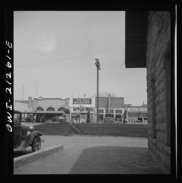
Central and Washington, with Lerner Shops, movie theaters, and streetcar tracks.

Cactus Streetlight 1940

The famous saguaro streetlamp across from the Hotel Westward Ho. Only one was made, outside the Chamber of Commerce.

Police and fire in early Phoenix

Police and fire in early Phoenix

Henry Garfias
Henry Garfias, the son of a Mexican general, was elected Phoenix's first town marshal in 1881. Already famous for apprehending the stagecoach "ghost bandit" as a county deputy, Garfias (above, courtesy of Duran Lugo) was said to have shot dead several outlaws as marshal and brought order to Washington Street's Whiskey Row (16 saloons and four dance halls). Thus was born the Phoenix Police Department.

The department operated out of the old City Hall until it received a more modern space in the City-County Building in 1929. Call boxes were used throughout the city for officers to check in. Phoenix equipped its squad cars with radios in 1932. You can learn more about PPD's history from the Phoenix Police Museum, located in the 1929 Police Headquarters at 17 S. Second Avenue. My new novel, City of Dark Corners, is set in the Depression-era department.

The Phoenix Fire Department came from passage of a bond issue in 1886 to establish a volunteer fire service with modern equipment and an improved water supply. Still, two hose companies (one Anglo, one Hispanic) competed until Frank Czarnowski joined them together as the Phoenix Volunteer Fire Department in 1888. By 1922, it was a paid, full-time department.

Here are some early photos (click for a larger image):

Nott steam fire engine

A Nott steam fire engine, one of Phoenix's first (City of Phoenix).

Fire_Station_horses_1st_St_Jefferson_1908_SHR copy

Horse-drawn apparatus at Fire Station No. 1, First and Jefferson streets, in 1908 (McCulloch Bros. Collection/ASU Archives).

Rural scenes of old Phoenix

Rural scenes of old Phoenix

Before "master planned communities," freeways, gravel, palo verdes, and endless pavement, Phoenix was closely surrounded by groves and farms, shade trees and virgin desert. It lasted until the 1960s and 1970s. I remember my grandmother taking me for a picnic on a dirt road surrounded by fields and beneath a cottonwood tree. Here are a few of the photos (click for a larger image):

Country_Road_Salt_River_Valley_1909(1)

Central and Southern 1930

Arizona willows or ash trees line Central and Southern avenues, 1930 (McCulloch Bros. Collection/ASU Archives).

Central and Southern 1930.jpg

Another view of shady Central at Southern in 1930 (McCulloch Bros. Collection/ASU Archives).

LincolnDriveWestof ScottsdaleRd_1935

Lincoln Drive west of Scottsdale Road in 1935.

Orangewood Ave. 1939

Orangewood Avenue in 1939 (McCulloch Bros. Collection/ASU Archives).

Mac

Mac

48385338_2312414719014622_7917882964497661952_o
When today's Arizonans think about the state's most important U.S. Senators, they go to Barry Goldwater and John McCain. A few will remember Carl Hayden, one of the longest-serving members of the Senate and, after the assassination of President John F. Kennedy, third in the line of succession to the White House.

Yet Goldwater, although the father of the right-wing takeover of the Republican Party, had a thin layer of legislative accomplishments, and McCain did almost nothing for the state he made his home. Hayden was undeniably the most important figure in winning the Central Arizona Project in Congress.

The Arizona Senator who casts the longest shadow of accomplishments is nearly forgotten: Ernest McFarland. First elected in 1940 when he defeated incumbent Henry Fountain Ashurst, Mac was an important partner with Hayden in fighting for Arizona's share of Colorado River water. His most significant accomplishment was sponsoring the GI Bill, which provided benefits for returning benefits for returning World War II veterans, including educational benefits.

Mac was the father of the GI Bill. He also served as Senate Majority Leader from 1951 to 1953, followed by Lyndon Johnson.

When Midtown cooked

When Midtown cooked

GB Bldg 1964


Midtown wasn't planned. It simply escaped…any coherent city planning, zoning, or vision. Some say it was Phoenix's attempt at Los Angeles' Wilshire Boulevard, the nearly 16-mile avenue from downtown LA's financial district to Santa Monica. Maybe. But Phoenix never had the economic power or urban assets to support its version of Museum Row on the Miracle Mile, Century City, Koreatown, Beverly Hills, Westwood with UCLA, and subway lines. Wouldn't want to become another LA.

The two are comparable in that both were the sites of a majority of post-1960 skyscrapers. In Phoenix, it began with the building above. A turquoise-skinned International-style box, the Guaranty Bank Building opened in March 1960, designed by architect Charles Polacek and built by contractor David Murdock (who lived a remarkable life). At 252 feet, it dethroned the Hotel Westward Ho as the tallest building in Phoenix and the Southwest. On the top floor the Cloud Club offered a spectacular view.

Over the next thirty or more years, this was the heart of the city. For better and for worse.

The Camelback Towers was also complete in the photo (a mile north at Pierson). Park Central Shopping Center had replaced the Central Dairy in the late 1950s. Del Webb's Phoenix Towers at Central and Cypress Street, one of the few co-ops in the city, opened in 1957. Twin mid-rise office buildings were opened two blocks south of Thomas; they eventually included U-Haul's headquarters. Midtown, still unnamed, was coming together haphazardly. The central business district, including most shops and department stores, were still downtown (Fillmore to the railroad tracks, Seventh Avenue to Seventh Street).

Phoenix’s historic schools

Phoenix’s historic schools

1873 adobe schoolhouse Central Monroe

Once upon a time, schools weren't built to resemble prisons with walls and steel fences, along with no shade and heat-radiating concrete and gravel. Even in early Phoenix, most were built to inspire. In 1873 (above) an adobe school at Central and Monroe was the beginning of better to come. Here are a few — click on the photo for a larger view:

Central School  Central and Monroe  1899

Central School, shown in 1899, replaced the adobe structure. The town's population was about 5,500.

Monroe School 1914 postcard

Monroe School at Seventh Street and Monroe, 1914. The building was preserved and is now the Children's Museum of Phoenix, alas without the shade trees and grass.

More Arizona railroad images

More Arizona railroad images

In addition to my popular column and gallery on Phoenix Union Station, I've written about the Ghost Railroads of Arizona, the many lines that helped build the state that have mostly disappeared. Another column detailed the difficult enterprise of building railroads to Phoenix, ending its isolation. And most recently photographer Jack Delano's trip across northern Arizona during World War II. Many of these have additional photos, so check them out even if you read the text.

Now, a grab bag of railroad photos from the 1950s to today. A reminder: Phoenix is by far the largest city in North America without intercity passenger trains, mostly a failure of state government.

Click on the photo for a larger image:

1877 first locomotive in Arizona

The arrival of the first locomotive to Arizona Territory, Yuma 1877 (Library of Congress).

Sunset Limited 1950

The Sunset Limited, premier train of the Southern Pacific, on its way to Phoenix in 1950.

Black Widow

The only Southern Pacific passenger train that didn't take the Northern Main Line through Phoenix was the Argonaut, shown above with three "Black Widow" diesels up front and plenty of mail and express cars. The Argonaut passed through Casa Grande. The Black Widows were usually reserved for freight service.

Argonaut at Tucson

Baggage carts are waiting as the Argonaut arrives in Tucson in the 1960s (Bob Knoll photo).

Sunset Tucson 1970

In 1970, a year before the inception of Amtrak, Southern Pacific's Sunset awaits the highball at Tucson. Operating only every other day, the train was a shell of the former premier passenger train of the SP.

Reefer blocks Topock 1953

A Santa Fe train hauling a block of refrigerated boxcars ("reefers") near the Colorado River crossing at Topock in 1953. These cars also hauled Salt River Valley produce by the trainload when Phoenix was an agricultural empire.

Williams railroad yard

When Williams was still on the Santa Fe main line, it had a busy yard with a roundhouse, as well as a Harvey House passenger station. A line rerouting around 1960 left the town on the "Peavine" to Phoenix, losing the fleet of mainline passenger trains.

ATSF near Holbrook 1962 new U25BSanta Fe freight action on the double-track main line near Holbrook in 1962. The lead locomotive is a new U25B, General Electric's first independent entry into the American diesel market. It was nicknamed the U-Boat.

Wartime on the Santa Fe

Wartime on the Santa Fe

Flagstaff Rt. 66 from. depot 1943
In March 1943, the photographer Jack Delano made a remarkable journey across northern Arizona on the main line of the Atchison, Topeka and Santa Fe Railway. He was working for the federal Office of War Information, documenting the massive work railroads were doing bringing troops and war materiel to both the European and Pacific theaters. In the process, he gave us images of small-town Arizona stretched along the railroad and U.S. Route 66. For example, above is downtown Flagstaff seen from the old depot looking across "the Mother Road." Flag's population was about 5,000.

Between 1941 and 1944, American railroads carried 83% of the increase in all traffic, along with 91% of all military freight and 98% of military personnel. Pullman put its thousands of sleepers into the effort and built thousands more troop sleepers and kitchen cars. The Santa Fe through northern Arizona, a critical route to the West Coast, saw a 175% spike in freight traffic. More than 1,000 cars a day went through the Albuquerque division headquarters of Winslow, with its 33-track yard and massive roundhouse and shops, along with passenger and troop trains.

The Southern Pacific through southern Arizona, including wartime Phoenix, saw similar challenges. But it didn't have a Jack Delano to document it.

This gallery comes from the Library of Congress. Click on a photo to see a larger image.

ATSF tank train 1943Passing a freight train carrying M-3 Lee tanks from the Arsenal of Democracy.

Superstition Vistas

Superstition Vistas

Superstition_Mountains_1940s
In 1977, when I was working on the ambulance as an EMT-paramedic, I was temporarily exiled from the city and worked for Aids Ambulance (the former Mesa Ambulance Service). This involved rotating to stations in Mesa, Tempe, Chandler, and Apache Junction. At the latter, two 24-hour units were maintained and the crews could expect major trauma calls, even lake rescues, in largely empty country. We proclaimed ourselves the Junction Medics. Superstition Mountain loomed to the east, not unlike the late 1940s photo above.

In those days, we left behind Mesa around Gilbert Road and were enveloped by massive citrus groves. This continued for about 12 miles, broken only by an occasional trailer park. Not much was out here. AJ's population was closing in on 9,000.

We christened Rossmoor Leisure World, a pioneering gated property, "Seizure World" because of the nature of calls from its elderly retired population. Williams Air Force Base sat miles to the south, down two-lane roads crossing farmland. Completion of the freeway was years away, so Main Street in the Maricopa County part of our territory wasn't even named or part of Mesa. It was four-lane U.S. 60, primevally dark at night, no curbs or sidewalks, lethal to pedestrians. Otherwise, it was empty desert all the way to the iconic mountain.

I couldn't imagine it would be anything else.

Fast forward to the 2000s. Mesa had ballooned from 63,000 in 1970 to nearly 400,000, grown all the way to the Pinal County line. The little suburbs I served had grown supersized and merged together into a sprawling conglomeration called the East Valley. The groves and farms were gone. Superstition's slopes were profaned by subdivisions. And all that empty desert was the most coveted piece of land in central Arizona. The boosters called it Superstition Vistas.

Central through the years

Central through the years

The trouble with Central Avenue is it's not central to anything now." So a real-estate mogul told me in 2001. He was totally bought into endless sprawl at the expense of Phoenix, but he was also wrong. With the metroplex spread from Buckeye to Gold Canyon, Phoenix's most important street is more important and convenient than ever, as has been shown by light rail (WBIYB)  and growing infill.

I've written about Central before. But let's take a photo journey, thanks to Brad Hall's collection, the McCulloch Bros. Collection/ASU Archives, and Library of Congress. Click for a larger image.

Central_Washington_road_construction_looking_south_1890s

When it was Center Street, a southward look at Washington in the 1890s. Construction workers are installing water lines.

CentralAdams1909Here's a view of the Hotel Adams in 1909. It burned down a year later and was replaced by a "fireproof" hotel.

Center Street BridgeThe Center Street, the first across the Salt River. Completed in 1910, the 2,120-foot-long span was claimed to be the longest reinforced concrete bridge in the world.

Commerce in old Phoenix

Commerce in old Phoenix

The McCulloch Brothers, who have left a priceless archive at ASU, were primarily commercial photographers. Their work, which spans from 1884 to 1947, offers a variety of images of business in the young, growing city. Most of this gallery is thanks to them.

You can read about the decades on these earlier history columns: Phoenix at statehood, the twenties, the thirties, the forties, and the fifties. Enjoy and click on the photo for a larger image.

McCulloch_Brothers_Photography_studio_18_N_2nd_Ave_1920s(1)

The McCulloch Brothers photography studio, 18 N. 2nd Avenue, in the 1920s.

Apache Trail Stage McC

A downtown sidewalk scene circa late 1910s with the Arizona Cigar Co. and the Apache Trail Auto Stage Co.

Washington St 1928Washington Street, the city's main commercial drag in 1928. Awnings helped keep pedestrians cool.

Floyd_Ikhard_Household_Appliances_831_N_1st_Ave_1945(1)

Floyd Ikhard Household Appliances, 831 N. 1st Avenue, in 1945.

Barker_Bakery_123_N_1st_Ave_1940s(1)

Barker Bakery, 123 N. 1st Avenue, in the 1940s.

OverlandMotors_10WVanBuren_1920sOverland Motors at 10 W. Van Buren in the 1920s. These blocks of the city would become the main location of auto dealers.

Phoenix_Motor_Company_Chevrolet_Buick_401_W_Van_Buren_1940sPhoenix Motor Co., a GM dealership, was at 401 W. Van Buren Street. It's been restored as The Van Buren, a concert venue.

Miracle Mile

Miracle Mile

I don't know when the stretch of east McDowell from 10th Street to beyond 16th Street received this nickname. It's certainly not the legendary shopping destination of Chicago. But I do know it was Phoenix's first major retail-commercial artery outside of the downtown central business district. (Grand, Van Buren, and 17th Avenue/Buckeye were mostly motels, restaurants, and "curio" shops for travelers).

The Miracle Mile was special because it had an urban fabric missing from any other part of the city outside, even Midtown and Uptown on Central Avenue. The commercial buildings were densely packed, most right up on the sidewalk. McDowell was only four lanes wide. The result was walkability missing in most parts of a city built for the automobile.

McDowell's businesses continued beyond 16th Street and, going west, to Seventh Avenue. However, the Miracle Mile most exemplified urban authenticity. No wonder efforts are under way to reinvent the stretch. Included is a public art arch. Sadly, they face the headwinds of demolished buildings and a six-lane McDowell which is much more dangerous for pedestrians, especially at night.

A footnote: When I was around nine some friends and I rode our bikes along the mile, then turned around and came back — on the sidewalk but against traffic. I raced to catch up with them when a car pulled out from a side street. I hit the fender and tumbled over the hood, landing on the pavement. The terrified driver picked me up from the asphalt (which you shouldn't do) and carried me to the sidewalk. There an ambulance (Phoenix Ambulance, where I would work a decade later) took me to Good Sam to await my mother and grandmother. I got away with a mammoth bruise on my upper leg.

Come with me on a tour of the historic Miracle Mile (click for a larger image):

Kenilworth centennial

Kenilworth centennial

Kenilworth_Elementary_School_(2)
My name and graduation date are etched in one of these bricks, which were installed to mark the 80th anniversary of my alma mater. I was honored to be one of the speakers. As for the bricks, they looked poorly carved so you might have to look hard to find those of us who paid to have our names on them. But the important thing is that Kenilworth survives, thrives, and this year celebrates its 100th anniversary.

Kenilworth was the grandest of several handsome elementary schools completed in that era, including Monroe, Grace Court, and Booker T. Washington. It was in the neighborhood that initially had the same name, where Phoenix's elite moved. Now it's the Roosevelt and F.Q. Story historic districts. But that, and the ill-considered Papago Freeway inner loop, were far in the future in 1920. Then the streetcar ran along Fifth Avenue.

By the time I came along, in the 1960s, the streetcar was gone. But Third Avenue ran straight in front on the school, no curve for the freeway onramp. Seventh Avenue was only four lanes wide with a friendly crossing guard named Paul. We lived on Culver Street when I was in first and second grades, then moved to Cypress in today's Willo historic district for the remainder of my time there.

Railroads to Phoenix

Railroads to Phoenix

First Tempe RR bridgeTempe History Museum photo

The recent derailment and fire of a Union Pacific train on the Salt River bridge is a reminder that railroads still play a role in Phoenix, even if far less than in the past. As the late David Myrick explained in his seminal Railroad of Arizona: Phoenix and the Central Roads, eight attempts were made to build a line to the Salt River Valley before the Maricopa and Phoenix Railroad's first train arrived on July 4th, 1887.

Among the many impediments — capital, supplies, heat, permission of the Pima Indians to cross their reservation — bridging the fickle Salt River was among the most persistent. The bridge above shows a "ten-wheeler" steam locomotive and two cars on the second iteration of the span. The first saw a flood destroy its approach trestle in 1890, then was severed entirely by the Great Flood of 1891, which also did substantial damage to canals and farmland; adobe structures collapsed from the rain.

In 1902, part of the bridge gave way without warning, dropping the locomotive 20 feet into the riverbed, killing one and severely injuring another, and leaving a passenger car hanging precariously. In 1905, the flooded Salt washed away a segment of this second bridge just minutes after a passenger train had crossed it. Similar washouts plagued the railroad's crossing of the Gila River.

Finally, the current heavy steel truss bridge was built in 1912-1913. UP says it will rebuild it — or at least replace one of the truss spans — which is good news for continued freight and potential future passenger service. Given Wall Street's pressure to suck profits from major railroads and Phoenix's relative unimportance on the system, I'd be surprised if UP built an entirely new and modern bridge.

Such was not always the case.

Phoenix, 1968

Phoenix, 1968

RFK Christown 1968Sen. Robert F. Kennedy campaigning at Chris-Town mall on March 30th, 1968, soon after announcing his candidacy for president. He would be dead from an assassin's bullet less than three months later.

Some are comparing this year's unrest to 1968 — not persuasively, to my mind — so it might be interesting to check in on Phoenix during that tumultuous year. Just what a different world this was is evident in a headline of the Arizona Republic on Monday, January 1st: "All The World Gay As Old Year Dies." Cultural language wasn't the only difference. The overnight low was 35 degrees, common then as Phoenix had several frosts each winter. The low would hit freezing later in the week. These are much more rare today amid the human-caused heat island. The paper carried Today's Prayer on the front page, as it had for years.

The sixties were a period of great change in Phoenix, where the magic of the old city's oasis was very much alive but the suburbanized future was coming — Maryvale and Sun City were abuilding. The city grew 32% during this decade. The city also entered the big leagues of sports in 1968 with the NBA expansion team Phoenix Suns.

Downtown was still a major retail center at the beginning of the decade, but it was in decline by 1968, hollowed out by Park Central and other malls, as well as low-cost retail buildings bulldozed to create Phoenix Civic Plaza with its convention center and Symphony Hall. This also leveled many single-room occupancy hotels and other parts of the Deuce. Critics warned the shattering of the city's skid row would send vagrants to nearby neighborhoods, which it did.