Aviation in old Phoenix

Aviation in old Phoenix

Balloon over Phoenix  Second St Adams 1911

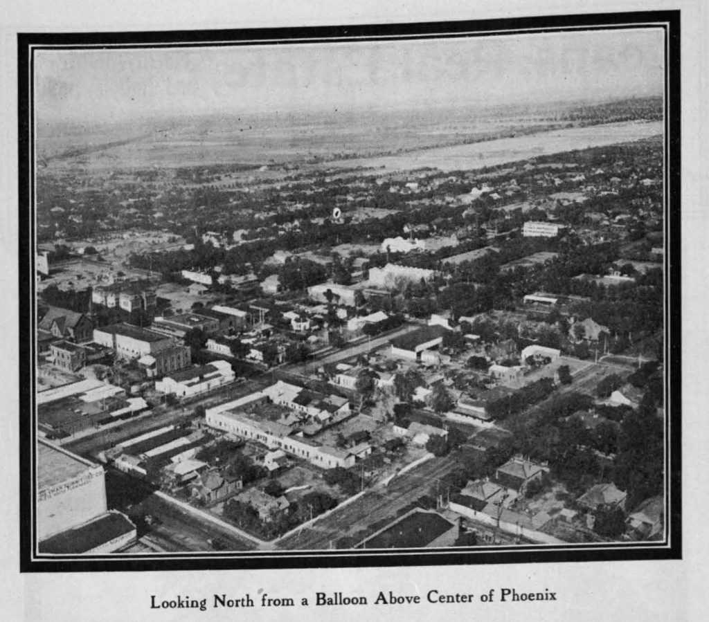
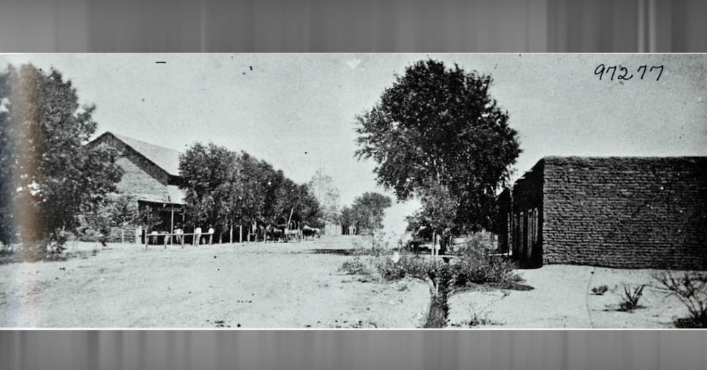
A year before statehood, a balloon went aloft to take this photo centered on Second Street and Adams (click for a larger image).

Frank_Luke

Fighter ace Lt. Frank Luke, a Phoenix native, gained fame in World War I as the "Arizona Balloon Buster" for his success against German observation balloons as well as enemy aircraft. Here he is with 13th confirmed kill. He was shot down and fatally wounded two months before the end of the war. German soldiers buried Luke in the Murvaux cemetery; Americans retrieved his body two months later. He received the Medal of Honor and Luke Air Force Base is named after him. 

Amelia Earhart at Phoenix S Central Airport  1931  UCS libraries

Amelia Earhart visiting Phoenix at the South Central Airport in 1931 (USC Libraries).

Sky_Harbor_aerial_looking_west_1930s

An aerial view of the land Phoenix purchased for its new airport in 1935, called Sky Harbor (McCulloch Bros. Collection/ASU Archives).

Hospitals of old Phoenix

Hospitals of old Phoenix

Good Sam 1930s

Good Samaritan Hospital facing McDowell Road in the 1930s. Its history can be traced to Lulu Clifton, a deaconess in the Methodist Church who established Deaconess Hospital in 1911. In 1917, it was moved to remote 10th Street and McDowell and renamed Good Samaritan in 1928 (McCulloch Bros. Collection/ASU Archives).

Deaconess_Hospital_1920s

Deaconess Hospital in the early 1920s before it was renamed.

Good Sam east wing 1930s

The east wing of Good Sam in the 1930s. The shady, grass cooled grounds of the hospital lasted into the 1970s (McCulloch Bros. Collection/ASU Archives).

GoodSam_1940s

A color postcard shows the hospital in the same era.

Parks of old Phoenix

Parks of old Phoenix

Phoenix_Block_numbers_1881_map

The original townsite set aside room for a park (plaza) on Block 23, site of today's downtown Fry's supermarket. You can click on each image for a larger view.

City_Hall_territorial_Washington_1st_St_front_view_gazebo_1912 copy

It became City Hall park, Phoenix's first, with a gazebo and shade trees (Brad Hall collection).

Gazebo_1905

In 1905, the park was welcoming people for a concert. Easy access was provided by the Washington Street streetcar (McCulloch Bros. Collection/ASU Archives).

The Central Arizona Project

The Central Arizona Project

Mark Wilmer Pumping Plant

The Mark Wilmer Pumping Plant, which draws water from Lake Havasu and vaults it 3,000 vertical feet over the Buckskin Mountains on the way 336 miles to Phoenix and Tucson. Wilmer and Charlie Reed were the lead lawyers in winning the landmark Arizona v. California lawsuit, guaranteeing the CAP. The plant accounts for 50% of the $4 billion CAP's energy use (Central Arizona Project photo).

1922-Colorado-River-Compact-signed

In 1922 the Colorado River Compact — cornerstone of "the Law of the River” — was signed by states of the Upper and Lower basins. Arizona didn't ratify it until 1944, complaining it apportioned water to the basins rather than to individual states (Library of Congress).

Parker Dam looking southwest

Parker Dam, completed in 1938, impounding the Lake Havasu reservoir. California put the first "straw in the river" here with the Colorado River Aqueduct. It was conceived by the legendary William Mulholland and completed in 1939 (Library of Congress).

The famous in old Phoenix

The famous in old Phoenix

For a frontier town grown large, old Phoenix had its share of visiting statesmen, heroes, and celebrities. Here are a few (click for a larger image).

McKinley in Phoenix May 1901
President William McKinley visited the capital of Arizona Territory in 1901, a few months before his assassination.

First car 1902 Dr. James Swetnam Winton

Dr. James Swetnam Winton with the first automobile in Phoenix, 1902.

President Taft 1909 Melinda's Alley

President William Howard Taft passes Melinda's Alley in 1909.

Theodore_Roosevelt_Heard_home_Maie_1911

Theodore Roosevelt at the Heard home in 1911, here for the dedication of Theodore Roosevelt Dam.

More Phoenix in the 1930s

More Phoenix in the 1930s

Phoenix went from Depression to a recovery earlier than most places thanks to abundant New Deal investments. Have a look in the photo time machine (click for a larger image):

Agua_Fria_River_Project_1932
The privately funded Agua Fria River Project, shown in this 1932 map, was derailed by the Great Depression. It sought to bring water to cultivate land all the way to the White Tank Mountains.

Frog Tanks dam 1926

One part of the Agua Fria Project survived as the "Frog Tanks Dam," under construction in 1926. The dam, later the Old Waddell Dam, was located on the Agua Fria River northwest of Phoenix. William Beardsley, a champion of the project, hired civil engineer Carl Pleasant to design the dam. Today, the dam has been replaced by a higher, longer structure that holds back a larger Lake Pleasant as part of the Central Arizona Project (McCulloch Bros.Collection/ASU Archives)

Alhambra_Garage_Seaside_Gasoline_Thomas_Rd_Grand_Ave_1930s(1)

Thomas and Grand Avenue in the 1930s, the Alhambra Garage and a nearby grocery, with a Holsum Bakery truck making a delivery (McCulloch Bros. Collection/ASU Archives).

Boehmers_Cut_Rate_Drugs_Monihon_Building_Washington_1st_Ave_1937

Boehmer's Cut-Rate Drugs in the Monihon Building at First Avenue and Washington Street in 1937. My fictional private investigator Gene Hammons has his office in this location (McCulloch Bros. Collection/ASU Archives).

The old High Country

The old High Country

Before land swaps and subdivisions in the pines, before a Super Walmart in Payson and wildfires started by the likes of Valinda Jo Elliott, the Arizona High Country was wild and lightly populated. Click on a photo for a larger image:

Heber_loggers(1)

Loggers working between Heber and Overgarrd in the late 19th century.

Pack mules in Payson 1901

Pack mules heading into Payson, 1901 (ASU Archives).

Payson General Store

The Payson General Store (ASU Archives).

Russell Lee’s Arizona

Russell Lee’s Arizona

Russell Lee (1903-1986) is a photojournalist best known for his work with the New Deal's Farm Security Administration. Some of his work documenting Depression-era Phoenix is iconic. He also worked around Arizona circa 1939-40. Here's a sample from the Library of Congress:

Apache National Forest

An unknown location in the Apache National Forest in far eastern Arizona.

Bird Cage Theater Tombstone

The Bird Cage Theater in Tombstone.

Tombstone Epitaph

Office of the Tombstone Epitaph. It is the oldest continually published newspaper in Arizona.

Bisbee main street

Main Street in Bisbee.

Grand Avenue

Grand Avenue

Grand Avenue never lived up to its splendid name. It continued as U.S. 60 from Van Buren Street northwest, picking up the companion Santa Fe Railway at 19th Avenue on the way to Wickenburg and eventually — in pre-Interstate days — to Los Angeles. Let's take a tour through the years. Click a photo for a larger image.

SaltRiverValleyMap_1892

In 1892, this map shows Grand Avenue running to Glendale, Peoria, and beyond.

Map_Phoenix_1915

This 1915 map shows how Grand was the only street to break the ordinary street grid of Phoenix.

Joseph_Johns_Grocery_1007_Grand_Ave_Holsum_ad_1920s(1)

Narrow and under a shade canopy, here's Grand Avenue in the 1920s. Joseph John's Grocery at 1007 Grand (McCulloch Brothers Collection/ASU Archives).

Grand Avenue at the corner of Lateral 4 near Thomas Rd.

Grand near Lateral 4 near Thomas Road, looking southeast, in the 1930s (McCulloch Brothers Collection/ASU Archives).

Alhambra_Garage_Seaside_Gasoline_Thomas_Rd_Grand_Ave_1930s(1)

Another view of Grand and Thomas, circa 1930 (McCulloch Brothers Collection/ASU Archives).

Grand_Ave_Thomas_looking_northwest_1940s(1)

The same location looking northwest in the 1940s (McCulloch Brothers Collection/ASU Archives).

More Valley towns

More Valley towns

Another look at some of the distinct towns and villages of the Salt River Valley before the blob of sprawl consumed them. Click on a photo for a larger image:

Avondale:

Avondale street scene 1946

Avondale street scene, 1946 (McCulloch Bros. Collection/ASU Archives).

Avondale_Market_Schneider_Drugs_12_E_Western_Central_Western_1945(1)

Avondale Market and Schneider Drugs, 1945 (McCulloch Bros. Collection/ASU Archives).

Schneiders_ Drug_Store_12_E_Western_Western_Central_Avondale_1945(1)

Another view of Schneider Drugs, 1945 (McCulloch Bros. Collection/ASU Archives).

Avondale_Grocery_Coldwater_Grocery_Store_Central_Western_1940s(1)

Coldwater Drug Store featuring Phoenix's famous Donofrio's ice cream in the 1940s (Brad Hall collection).

Avondale SP depot

The Avondale Southern Pacific depot, circa 1926 (Arizona Archives Online).
 

Buckeye:

Buckeye 1930s

Downtown Buckeye in the 1920s. Founded in 1888, it was originally named Sidney after the hometown of settler Malie Jackson. It was changed to Buckeye to honor his home state of Ohio (McCulloch Bros. Collection/ASU Archives).

Buckeye depot

Buckeye's Southern Pacific depot in an undated photo. The platform is for unloading boxcars. In 1926, completion of the SP Northern Main Line placed Buckeye on a transcontinental railroad.

1327px-Buckeye _Maricopa_County _Arizona._Private_auto_camp_for_cotton_pickers _camp_manager's_store_in_for_._._._-_NARA_-_522538

Depression-era housing for cotton pickers in Buckeye.

1756px-Buckeye-Buckeye_Union_High_School_A-Wing-1

Buckeye Union High School, built at Buckeye High School, built in 1921.

When Scottsdale was real

When Scottsdale was real

After I finished grade school at Kenilworth north of downtown Phoenix, we moved to Scottsdale (population 68,000) so I could attend Coronado High School. My mother was alarmed by news that a gang of teenagers had kicked a West High student nearly to death. I lucked out, going four years and graduating from one of the nation's best public secondary schools, with a superb fine arts program and academics. And I got to see Scottsdale before it became so rich and big and fake, Silicone Valley with its plastic surgery and a city limits reaching all the way to the Tonto National Forest.

Here's how "the West's Most Western Town" was in those decades. Most of the gallery is thanks to Brad Hall's collection. Click on a photo for a larger image:

Brown_Ave_Scottsdale_1950s

Brown Avenue in the 1950s. Scottsdale's population was a little more than 2,000 in 1950 (Photographer unknown).

Lulu_Belle_Main_Scottsdale_Rd_1950s(1)

The Lulu Belle at Scottsdale Road and Main Streets (Photographer unknown).

Main_Street_Scottsdale_1950s(1)

Main Street in the 1950s. It was much the same in the 1970s (Photographers unknown):

Fiffth Avenue 1970s

The art of American Eden

The art of American Eden

In the first half of the 20th century, the produce of the Salt River Valley traveled to customers in the east via refrigerated boxcars (reefers), iced before they left the Warehouse District packing houses and others in Glendale and Peoria, and along the route. But the wooden crates and later cardboard boxes were decorated with vivid illustrations that advertised the produce — and created a distinct art form. Almost all were done by anonymous artists.

Here is a sample. Click for a larger image:

Ariz Sun 1936

ArizGlo

More early Phoenix 3

More early Phoenix 3

Phoenix grew from 270 people in 1870 to 11,314 in 1910. Here's a gallery of our town before statehood. Most are from the Library of Congress or Brad Hall. Click on a photo for a larger image:

Phoenix 1870s

Phoenix in the 1870s. Lots of shade trees and not a palo verde in sight.

12-mule teams 1st and Jefferson 1880s

Twelve mule-team freight haulers at Montezuma Street (First Street) and Jefferson in 1880, before the railroads arrived. Look at all the shade trees.

2nd St and Jeff 10-mule team freighter 1880s

Another view of how goods were delivered. This is at Maricopa Street (Second Street) and Jefferson.

Capitol_construction_1889

The territorial capitol under construction in 1898.

Capitol_territorial_1901(1)

And completed in 1901.

Adams_east_of_Central_looking_southwest_Hannys_1890s

Adams Street east of Center, looking southeast circa 1890. It's near the future site of Switzers and Hanny's.

1st_St_Monroe_looking_northeast_Melindas_Alley_1890s

Looking northeast up Melinda's Alley near Mojave Street (First Avenue) and Monroe in the 1890s.

USS Arizona

USS Arizona

USS_Arizona_(BB-39)_1930 after moderniz
Arizona had barely been in the union for two years when the keel was laid on battleship 39 (BB-39) at the Brooklyn Navy Yard, named after the 48th state. In attendance was Assistant Secretary of the Navy Franklin D. Roosevelt.

Battleships were the premier capital ships of any navy and had been revolutionized by the 1906 launch of the Royal Navy's HMS Dreadnought, the first all-big-gun ship. It lost the smaller-caliber weapons of its predecessors in favor of batteries of deadly 12-inch guns that could hurl shells for miles. The ship took its name from Queen Elizabeth I's saying, "I will trust in God and dread nought." This gave the name to all classes of future battleships.

Arizona, according to the New York Times, would be "the world's biggest and most powerful, both offensively and defensively, superdreadnought ever constructed." It was armed with three batteries of three 14-inch big guns each, with a range of 12 miles. The armor belt at its widest (made by Krupp) measured 13.5 inches; the deck was also armored. She was 608 feet long and displaced nearly 30,000 tons, becoming at the time the largest ship in the fleet (today’s new Gerald R. Ford carrier is 100,000 tons and more than 1,000 feet long).

Arizona was launched in 15 months with 75,000 people in attendance, including the state's governor, George W.P. Hunt. Esther Ross of Prescott christened her with two bottles, one of sparking wine and another of water from Theodore Roosevelt Lake (the state had recently passed prohibition).

Phoenix’s architectural icons

Phoenix’s architectural icons

In an earlier column, I wrote about Phoenix's influential architects from Frank Lloyd Wright to Will Bruder (who decamped for Portland). Here is a gallery of the most iconic and beautiful structures from the past and present, from the McCulloch Bros. Collection/ASU Archives, Library of Congress, and Brad Hall. Click on a photo for a larger image.

1st_Ave_Washington_looking_northwest_Fleming_1938

The Fleming Building at First Avenue and Washington in 1938. It was completed in 1883, the most impressive building in the young town. Among its amenities: A basement bowling alley and two rooms as the first public library. It was demolished in the 1980s for the boxy Wells Fargo Building.

AZcap

The State Capitol at 17th Street and Washington, completed in 1901 as the territorial capitol. The Legislature never funded a replacement statehouse, although architecturally compatible additions were made. Modernistic structures for the House and Senate were added in the 1960s, and the scene was marred by the 1974 Executive Tower behind it. The Capitol is now a museum with its copper dome.

Center_Street_Bridge_1911

The Center Street Bridge, first span across the Salt River connecting farmers with the city and its railroads. Completed in 1911, it was claimed to be the longest reinforced concrete bridge in the world.

Hotel_Adams_Central_Adams_looking_northeast_1940s(1)

The Hotel Adams, built to replace an 1896 wooden structure that burned in 1910. It was demolished in the mid-1970s for today's Renaissance Hotel (first named the new Hotel Adams).